 Filter: Categories of Wisconsin Historical Images
Filter: Subject of Rivers
Filter: Year of 1900-1999
Filter: Year of 1960-1969
Filter: Year of 1962
Filter: Categories of Wisconsin Historical Images
Filter: Subject of Rivers
Filter: Year of 1900-1999
Filter: Year of 1960-1969
Filter: Year of 1962
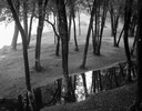
| Date: | 09 22 1962 |
|---|---|
| Description: | Elevated view of trees and pool of water near the Wisconsin River in Pauquette Park. |

| Date: | 08 05 1962 |
|---|---|
| Description: | Mr. Ortel, a United States Government lock-keeper at Appleton lock number one on the Fox River canal. Mr. Ortel is opening the sluice gates to allow water ... |

| Date: | 08 05 1962 |
|---|---|
| Description: | Exterior view of Riverside Paper Corporation mill. On the left is a road along a river, and on the right are railroad tracks along the mill. A sign in the ... |

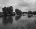
| Date: | 08 03 1962 |
|---|---|
| Description: | Elevated view of the Guard Lock on the Fox River Canal, looking east from the Highway 55 bridge. |
| Date: | 08 04 1962 |
|---|---|
| Description: | A boat travels up the Fox River. In the background are a canal and locks and factory smokestacks. |

| Date: | 07 21 1962 |
|---|---|
| Description: | A parking lot underneath a newly developed block of stores. The Rock River is visible just beyond the parking lot. There is a bridge in the background. |

| Date: | 08 04 1962 |
|---|---|
| Description: | A boat in the Fox River Canal, headed up river. This particular lock, the Ripide Croche Lock, is located just north of Wrightstown. |
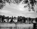
| Date: | 09 15 1962 |
|---|---|
| Description: | A group of men, women and children fish from a dock located on the Fox River. In the background are commercial buildings along the shoreline. |
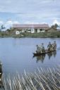
| Date: | 06 1962 |
|---|---|
| Description: | U.S. Army advisor Major M.C. Curley and soldiers crossing a river in the delta region of Vietnam in a small boat to visit an outpost. A large building, a m... |

| Date: | 1962 |
|---|---|
| Description: | An American soldier inspects the papers of a Vietnamese man in the countryside along a river. Vietnamese soldiers and a boy are grouped around him. |

| Date: | 1962 |
|---|---|
| Description: | Elevated view of a group of Vietnamese soldiers wearing berets hiking through a forest in Vietnam. The footpath they are on is bordered on one side by tree... |

| Date: | 06 1962 |
|---|---|
| Description: | Aerial view of old U.S. Army model H-21 helicopter, assigned to help Vietnamese forces fight the Viet Cong in the mountain region of Vietnam. The patchwork... |

| Date: | 05 1962 |
|---|---|
| Description: | Vietnamese Rangers escort a newly captured prisoner suspected of being Viet Cong down a gravel road in the vicinity of Bac Lien, Vietnam. The prisoner has ... |

| Date: | 1962 |
|---|---|
| Description: | This map shows the voting districts of Waukesha in red ink for the year 1962. The bottom of the map includes an index of streets. |

| Date: | 1962 |
|---|---|
| Description: | Field artillery piece of the First World War pointing across the Rock River from the grounds of the American Legion post. |

| Date: | 1962 |
|---|---|
| Description: | This map shows streets, points of interest, Lake Winnebago, Millers Bay, South Asylum Bay, Lake Butte des Morts, and the Fox River. The map also includes a... |

| Date: | 1962 |
|---|---|
| Description: | This map shows streets, points of interest, Lake Winnebago, Millers Bay, South Asylum Bay, Lake Butte des Morts, and the Fox River. The map also includes a... |

| Date: | 1962 |
|---|---|
| Description: | This map shows roads, golf courses, ski areas, boat landings, camp sites, waysides, parks, beaches, scenic views, virgin timber tracts, airports, boys and ... |
| Date: | 1962 |
|---|---|
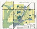
| Description: | This map shows zoning, community facilities, roads, rivers and thoroughfares. The lower right corner includes a key titled "General Plan". |

| Date: | 1962 |
|---|---|
| Description: | This tourist-oriented road map shows federal highways, state highways, county roads, and county lines in the "Blue Diamond Resort Area," a scenic space enc... |
If you didn't find the material you searched for, our Library Reference Staff can help.
Call our reference desk at 608-264-6535 or email us at: