Filter: Categories of Wisconsin Historical Images
Filter: Subject of Rivers
Filter: Year of 1900-1999
Filter: Year of 1960-1969
Filter: Year of 1965
Filter: Categories of Wisconsin Historical Images
Filter: Subject of Rivers
Filter: Year of 1900-1999
Filter: Year of 1960-1969
Filter: Year of 1965

| Date: | 05 31 1965 |
|---|---|
| Description: | Elevated view of Evangelical United Brethren church in the vicinity of Highway T. |

| Date: | 1965 |
|---|---|
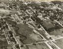
| Description: | Aerial view of downtown Big Falls and the Little Wolf River. The Little Wolf River is at lower right. |

| Date: | 03 16 1965 |
|---|---|
| Description: | Anthony Wise in a necktie and hat standing next to a Native American wearing a feather headress, on a boat adjacent to a dock. |
| Date: | 04 18 1965 |
|---|---|
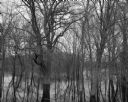
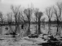
| Description: | View of a wooded area affected by a Wisconsin River flood. |
| Date: | 1965 |
|---|---|
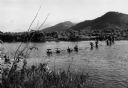
| Description: | View from shoreline of U.S. Marines wading across a river while on a "Search and Clear" operation near Da Nang in Vietnam. |

| Date: | 1965 |
|---|---|
| Description: | Artistic rendering of the Equitable Building at 401 N. Michigan Avenue. Includes the text "make yours the prestige address in Chicago — the dramatic new Eq... |

| Date: | 1965 |
|---|---|
| Description: | A map of Milwaukee County showing the county supervisor districts and the city wards. The map also includes the names of those on the on the board of elect... |
| Date: | 1965 |
|---|---|
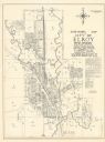
| Description: | Shows city limits, plat of town, local streets, railroads, and Baraboo River. "Revised by Mid-State Associates, Baraboo, Wisconsin, April 6, 1965" Upper ri... |

| Date: | 1965 |
|---|---|
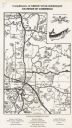
| Description: | Map shows original plat, plat additions, and lot measurements for Rothschild, Wisconsin. Lake Wausau and the Wisconsin River are labelled. Map reads: "Comp... |
| Date: | 1965 |
|---|---|
| Description: | This map shows lot and block numbers and dimensions, additions, streets, and railroads. |
| Date: | 04 03 1965 |
|---|---|
| Description: | From back of Pairing, "Flooded land partly covered by ice at Knapp's Creek (at junction with the Wisconsin River near Boscobel), Wis. View looking toward t... |

| Date: | 1965 |
|---|---|
| Description: | This map shows wards, city limits, railroad right of way, proposed future streets, and approximate street elevations. Wards and public schools are labeled ... |
| Date: | 02 25 1965 |
|---|---|
| Description: | This blue line print map shows annexed land with ordinance numbers and dates. |

| Date: | 1965 |
|---|---|
| Description: | This map shows 32 zoning districts, house numbering system, parks, cemeteries, and Milwaukee County institutional buildings. |

| Date: | 11 1965 |
|---|---|
| Description: | View looking down at a U.S. soldier, holding a rifle and carrying a radio unit on his back, sits on a large rock on a ridge overlooking a river. |

| Date: | 1965 |
|---|---|
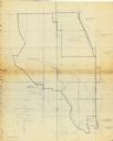
| Description: | This map shows landownership, acreages, and roads. The city of De Pere, the town of Hobart, and the Fox River are labeled. Inset maps showing Smits Subdivi... |

| Date: | 03 1965 |
|---|---|
| Description: | Keith Brigham is shown checking the U.S. Geological Survey stream gauging station located at the Yahara river locks on Lake Waubesa near McFarland. |
| Date: | 1965 |
|---|---|
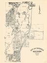
| Description: | This map covers the vicinity of Arbor Vitae, Woodruff, and Minocqua: east to Mishonagon Creek, west to Gilmore Lake, north to Lower Gresham Lake, and south... |
If you didn't find the material you searched for, our Library Reference Staff can help.
Call our reference desk at 608-264-6535 or email us at: