 Filter: Categories of Wisconsin Historical Images
Filter: Subject of Rivers
Filter: Year of 1900-1999
Filter: Year of 1970-1979
Filter: Year of 1970
Filter: Categories of Wisconsin Historical Images
Filter: Subject of Rivers
Filter: Year of 1900-1999
Filter: Year of 1970-1979
Filter: Year of 1970

| Date: | 1970 |
|---|---|
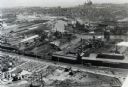
| Description: | Aerial view of International Harvester's Wisconsin Steel Works, with a river and Lake Michigan in the background. |
| Date: | 1970 |
|---|---|
| Description: | Aerial view of International Harvester's Wisconsin Steel Works (factory). |

| Date: | 05 05 1970 |
|---|---|
| Description: | Steve Landaal and two friends sit on a log over a creek at the Sound Storm rock festival. They are enjoying nude sunbathing. |

| Date: | 05 05 1970 |
|---|---|
| Description: | Steve Landall embraces his girlfirend while standing in a creek at the Sound Storm rock festival. |

| Date: | 1970 |
|---|---|
| Description: | A map of parks of Kewaunee County, Wisconsin, showing the fishing spots, lakes and parks in the area, it also provides a location map of the area. On the ... |

| Date: | 1970 |
|---|---|
| Description: | Elevated view of an International Harvester model MA-1500 Metro delivery truck is parked on a bridge overlooking a body of water and a city skyline, likely... |

| Date: | 1970 |
|---|---|
| Description: | Color coded map. Legend in the top left hand corner reads: "EXISTING AIRPORT PAVEMENT" (purple), "FUTURE 5-YEAR DEVELOPMENT" (bright pink), "ULTIMATE AIRPO... |

| Date: | 1970 |
|---|---|
| Description: | This map is intended for tourists of La Crosse. The cover features images of farms and natural land and reads: "friends are but strangers... we have yet to... |

| Date: | 1970 |
|---|---|
| Description: | This map shows lot and block numbers, city limits, cemeteries, schools, outdoor theater, Lumberjack Bowl, and Historyland among other attractions. |
| Date: | 1970 |
|---|---|
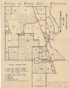
| Description: | This blue line map shows zoning districts in the Village of Brown Deer. Includes a key in lower left hand corner. Includes street names. The Milwaukee Rive... |

| Date: | 1970 |
|---|---|
| Description: | This map shows land owned by Menominee Enterprise Inc., land sold to Menominee shareholders, and land sold to non-Menominees. The map also includes water a... |
| Date: | 05 18 1970 |
|---|---|
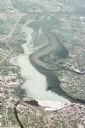
| Description: | Aerial view titled "Neenah Pollution." The view is looking north from over Neenah at Little Lake Butte des Morts which is discolored. |
If you didn't find the material you searched for, our Library Reference Staff can help.
Call our reference desk at 608-264-6535 or email us at: