 Filter: Categories of Wisconsin Historical Images
Filter: Subject of Rivers
Filter: Year of 1900-1999
Filter: Year of 1980-1989
Filter: Year of 1982
Filter: Categories of Wisconsin Historical Images
Filter: Subject of Rivers
Filter: Year of 1900-1999
Filter: Year of 1980-1989
Filter: Year of 1982
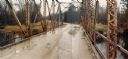
| Date: | 1982 |
|---|---|
| Description: | Bridge over the Lemonweir River in the Town of Orange, Juneau County. |

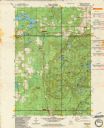
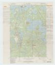
| Date: | 1982 |
|---|---|
| Description: | This standard U.S.G.S. topographic map was annotated by civil engineer and railroad historian James P. Kaysen to show the location of existing and defunct ... |
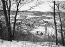
| Date: | 1982 |
|---|---|
| Description: | Bare trees frame an elevated view of Gays Mills taken from a snowy hilltop, showing Highway 131, lower right, as it curves into Main Street. Highway 171 en... |
| Date: | 1982 |
|---|---|
| Description: | This standard U.S.G.S. topographic map was annotated by civil engineer and railroad historian James P. Kaysen to show the location of existing and defunct ... |
| Date: | 1982 |
|---|---|
| Description: | This standard U.S.G.S. topographic map was annotated by civil engineer and railroad historian James P. Kaysen to show the location of existing and defunct ... |
| Date: | 1982 |
|---|---|
| Description: | This standard U.S.G.S. topographic map was annotated by civil engineer and railroad historian James P. Kaysen to show the location of existing and defunct ... |
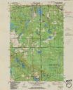
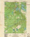
| Date: | 1982 |
|---|---|
| Description: | A map of the Hazelhurst quadrangle annotated with railroad information. |
If you didn't find the material you searched for, our Library Reference Staff can help.
Call our reference desk at 608-264-6535 or email us at: