 Filter: Categories of Wisconsin Historical Images
Filter: Subject of Rivers
Filter: Year of 1900-1999
Filter: Year of 1990-1999
Filter: Categories of Wisconsin Historical Images
Filter: Subject of Rivers
Filter: Year of 1900-1999
Filter: Year of 1990-1999

| Date: | 01 1993 |
|---|---|
| Description: | Horses and carriage at the east end of Henni Street in winter. |

| Date: | 04 1999 |
|---|---|
| Description: | With Shirley Widmer looking on, Chelsey and Logan Wilz and Parker and Carly Hren count their Easter eggs. |

| Date: | 05 1999 |
|---|---|
| Description: | 77 volunteers pick up trash and debris in the Rock River. Chuck Trauba and the crew covered the river from Theresa Marsh to the Theresa Disposal plant. 50 ... |

| Date: | 1992 |
|---|---|
| Description: | This guide features a map of suggested bike routes. Also included is a legend, text on how to use the map and legend, points of interest, and safety tips. |

| Date: | 1995 |
|---|---|
| Description: | Candid head and shoulders portrait of Gaylord Nelson. In the background is a body of water and trees. |

| Date: | 1990 |
|---|---|
| Description: | This map shows the Minnesota Point, Wisconsin Point, Hog Island, Baker's Island, Connors Point, Blatnik Bridge, Superior Bay, Allouez Bay, the Nemadji Rive... |
| Date: | 1998 |
|---|---|
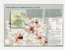
| Description: | This map shows the number of Welsh-born heads of households around 1870. A small inset map in the lower left corner shows Welsh land ownership in the heart... |
| Date: | 1990 |
|---|---|
| Description: | This map shows Wisconsin Central Ltd. main track, lines out of service, abandoned lines, and trackage rights. The map covers Wisconsin and Michigan's upper... |

| Date: | 1994 |
|---|---|
| Description: | This map shows historical sites, picnic grounds, public boat landings, canoe and motor boat trips, and resort locations. The left margin of the map include... |

| Date: | 1990 |
|---|---|
| Description: | This map includes two insets: Plat of New Holstein village and Village of Chilton. The map also includes a table of statistics showing the assessed value o... |

| Date: | 1990 |
|---|---|
| Description: | This map, in addition to the Fort ground and buildings, shows owners of outbuildings, heights of buildings in stories, fences, roads, gardens, and cemetery... |

| Date: | 1993 |
|---|---|
| Description: | Elevated view of a river. The trees are covered in snow, and line both shores of the river. The river is flowing free of ice. |

| Date: | 1993 |
|---|---|
| Description: | A small river winding through a farm field, with snow covering the banks and field. Trees and a house are on the horizon. |

| Date: | 1993 |
|---|---|
| Description: | View from shoreline looking down at a light film of ice covering the surface of a river as it curves around a bend towards a bridge in the distance. A path... |

| Date: | 1997 |
|---|---|
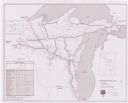
| Description: | System map including Wisconsin Central LTD., Fox Valley and Western LTD., Algoma Central Railway, Inc., and Sault Ste. Marie Bridge Co. Detail maps at top ... |
If you didn't find the material you searched for, our Library Reference Staff can help.
Call our reference desk at 608-264-6535 or email us at: