 Filter: Categories of Wisconsin Historical Images
Filter: Subject of Rivers
Filter: Year of 1900-1999
Filter: Year of 1930-1939
Filter: Categories of Wisconsin Historical Images
Filter: Subject of Rivers
Filter: Year of 1900-1999
Filter: Year of 1930-1939

| Date: | 1936 |
|---|---|
| Description: | This map is red and black ink on tracing cloth and is oriented with north to the upper left. This hand-drawn map shows a central portion of the military ro... |
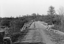
| Date: | 06 01 1936 |
|---|---|
| Description: | Bridge and truck trail constructed by Works Progress Administration (WPA) workmen to facilitate forest fire prevention and control. |
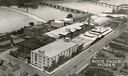
| Date: | 1931 |
|---|---|
| Description: | Aerial view of International Harvester's Rock Falls Works. The factory was owned by the Keystone Manufacturing Company until 1904, when the company was pur... |
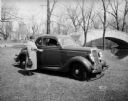
| Date: | 04 18 1935 |
|---|---|
| Description: | Miss Pyre standing next to a Ford V-8 coupe near a bridge at Tenney Park. A building with a tower is in the background, perhaps the Hausmann Brewing Compan... |
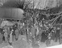
| Date: | 03 23 1934 |
|---|---|
| Description: | Crowd standing on the Thornton Avenue bank of the Yahara River at the Milwaukee Road railroad bridge looking at a car-train accident scene where Mrs. Clark... |
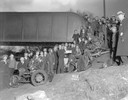
| Date: | 03 23 1934 |
|---|---|
| Description: | Crowd standing on the Thornton Avenue bank of the Yahara River at the Milwaukee Road railroad bridge looking at a car-train accident scene where Mrs. Clark... |
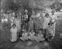
| Date: | 07 18 1932 |
|---|---|
| Description: | Marquette School children, with their drama teacher Ethel Kaump, in costumes for their play "The Fairy Woods," presented on the banks of the Yahara River. |

| Date: | 1937 |
|---|---|
| Description: | Bird's-eye view of Milwaukee in 1853 details building features and city layout from southwest. Important buildings are numbered in a silhouette drawing bel... |
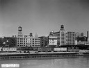
| Date: | 1933 |
|---|---|
| Description: | Chicago's Wacker Drive at Clark Street, looking north. Buildings, water towers and railroad boxcars are along the Chicago River waterfront, as well as a Co... |
| Date: | 1930 |
|---|---|
| Description: | The municipal sand-bottomed swimming pool was a popular spot to cool off in the summer months. |
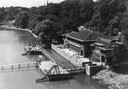
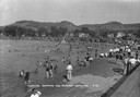
| Date: | 1930 |
|---|---|
| Description: | Sunbathers relax on the piers at the swimming park on the Milwaukee River. |
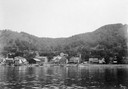
| Date: | 1930 |
|---|---|
| Description: | View of Alma from across the Mississippi River. |
| Date: | 1935 |
|---|---|
| Description: | Elevated view of the Portage canal and lock, with the Indian Agency House in the center background. The canal was dug in 1849 as part of the Fox-Wisconsin ... |

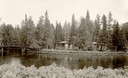
| Date: | 1930 |
|---|---|
| Description: | Aerial view of the city and the river. |

| Date: | 1930 |
|---|---|
| Description: | View of bridge and Brule River monument. Placed where the Brule River is crossed by the Memorial Highway from Superior to Brule and Ashland (Highway 2). |
| Date: | 1930 |
|---|---|
| Description: | Cedar Island on Brule River, a nationally known speckle trout stream. The island has native towering white pine and bubbling clear springs. These are some ... |
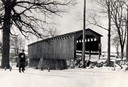
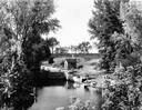
| Date: | 1934 |
|---|---|
| Description: | Southwest view of a covered bridge over Cedar Creek, with a man walking in the snow nearby. |
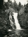
| Date: | 1935 |
|---|---|
| Description: | View from rocky shoreline towards the Brownstone Falls in Copper Falls State Park. |
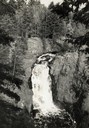
| Date: | 1935 |
|---|---|
| Description: | Elevated view of the Brownstone Falls on the Bad River. |
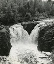
| Date: | 1937 |
|---|---|
| Description: | Elevated view of the waterfall where the Bad River tumbles over the Keweenawan Trap Ledge. |
If you didn't find the material you searched for, our Library Reference Staff can help.
Call our reference desk at 608-264-6535 or email us at: