 Filter: Categories of Wisconsin Historical Images
Filter: Subject of Rivers
Filter: Year of 1900-1999
Filter: Year of 1990-1999
Filter: Categories of Wisconsin Historical Images
Filter: Subject of Rivers
Filter: Year of 1900-1999
Filter: Year of 1990-1999
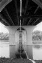
| Date: | 06 30 1992 |
|---|---|
| Description: | View from below of the Fox River Bridge. Gordon Neitzke who photographed the Fox River Bridge for the Wisconsin Department of Highways, found an almost cat... |
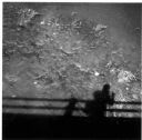
| Date: | 1992 |
|---|---|
| Description: | Self-Portrait of shadow from Lucinda Bridge above the Kishwaukee River. |

| Date: | 1999 |
|---|---|
| Description: | The Kishwaukee River in winter and its snow-covered banks. |

| Date: | 1994 |
|---|---|
| Description: | This brochure consists of a series of 16 maps of the Military Ridge State Park Trail and the Sugar River State Trail. In all, 62 miles of bike trails and 1... |

| Date: | 1991 |
|---|---|
| Description: | This canoe guide depicts the Wisconsin River from just north of Prairie du Sac to near Spring Green. Landmarks and points of interest are identified and de... |

| Date: | 03 1990 |
|---|---|
| Description: | "A huge build-up of foam occurred below the dam on the Rock River." |

| Date: | 07 1991 |
|---|---|
| Description: | "Les Beck draws water from the Rock River to water eight colorful flower boxes put up by the Theresa Lions Club." |

| Date: | 11 28 1992 |
|---|---|
| Description: | "This dam was constructed in 1917. Costs were funded by voluntary contributions totaling $206. Those who did not contribute were expected to donate their... |

| Date: | 01 02 1993 |
|---|---|
| Description: | "Horse-drawn carriage at the corner of Mill and Henni Streets." |

| Date: | 12 1994 |
|---|---|
| Description: | "When the Theresa Community Development Corporation had a naming contest for this park, Janet Schuster Checolinski was the winner, with 'Rivers Edge Park.'... |

| Date: | 05 1995 |
|---|---|
| Description: | "Pioneer reenactors set up their tents on the Rock River in Mayville." |
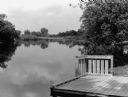
| Date: | 06 1996 |
|---|---|
| Description: | "This is the boat landing at Rivers Edge Park." |

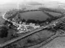
| Date: | 09 1996 |
|---|---|
| Description: | "Theresa's Bonduel & Wisconsin Streets from the air." |
| Date: | 09 1996 |
|---|---|
| Description: | "This is Theresa Station. Note the Rock River and Soo Line Railroad track." |
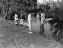
| Date: | 08 1998 |
|---|---|
| Description: | "Anglers try their luck on the Rock River (L-R): Logan Wilz, Joe Wilz, Carly Hren, and Chelsey Wilz." |

| Date: | 1990 |
|---|---|
| Description: | This late 20th century tourist map of Sauk County, Wisconsin, shows the highways and roads, cities and towns, parks, airports, canoe landings, hospitals, s... |

| Date: | 1991 |
|---|---|
| Description: | This 1991 map of Burnett County, Wisconsin, shows Governor Knowles State Forest, wildlife areas, public hunting grounds, and other outdoor recreation facil... |

| Date: | 12 1992 |
|---|---|
| Description: | Built in 1916, the Theresa Village Dam has played a large part in the appearance of the Rock River. Dam is pictured in winter. |
If you didn't find the material you searched for, our Library Reference Staff can help.
Call our reference desk at 608-264-6535 or email us at:

