 Filter: Categories of Wisconsin Historical Images
Filter: Subject of Roads
Filter: County of Dane
Filter: Creator Name of Gillett, Sherwin
Filter: Subject of botany
Filter: Categories of Wisconsin Historical Images
Filter: Subject of Roads
Filter: County of Dane
Filter: Creator Name of Gillett, Sherwin
Filter: Subject of botany
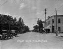
| Date: | 1924 |
|---|---|
| Description: | A view down street, which is lined with parked cars. There is a grocery store on the corner on the right, and beyond is a sign for a "Hotel Office". |
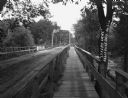
| Date: | 1912 |
|---|---|
| Description: | A bridge with both a wooden walkway for pedestrians and a dirt road for automobiles. Two men and a horse are standing on the other side of the bridge. |
| Date: | 1930 |
|---|---|
| Description: | View down middle of road of car driving across a bridge over Sugar River. Another car is parked by the Wisconsin Power and Light Company. |

| Date: | |
|---|---|
| Description: | View down an unpaved road with shops on either side. A horse and carriage is coming down the street, and another horse and carriage is parked in front of a... |

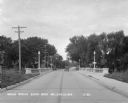
| Date: | 1925 |
|---|---|
| Description: | View looking down street with cars parked along the curb. There is a team of horses with a carriage on the right. |
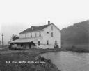
| Date: | 1925 |
|---|---|
| Description: | View along shoreline of a mill on a river. There is a man loading bags onto a cart at the front. There is a wooded hill on the right. |

| Date: | |
|---|---|
| Description: | View of the village from the railroad tracks. There is a church among the cluster of homes. |

| Date: | 1925 |
|---|---|
| Description: | A view looking up a winding road with rows of utility lines on both sides. The road is partially fenced. |

| Date: | |
|---|---|
| Description: | View from hill over church and cemetery towards fields and town in a valley. |
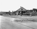
| Date: | |
|---|---|
| Description: | Exterior of a gas station/restaurant and the entrance to the Triangle Tourist Park. |
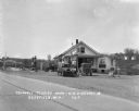
| Date: | 1929 |
|---|---|
| Description: | Exterior view from road of gas station and "dine and dance" restaurant on Highway US-18/US-12, outside the Triangle Tourist Park. The establishment offers ... |

| Date: | 1929 |
|---|---|
| Description: | Exterior of the Little Dutch Mill restaurant. The restaurant is designed in the style of a windmill. A sign on the lawn of the establishment reads, "ISO=VI... |

| Date: | 1929 |
|---|---|
| Description: | Exterior of the Twin Gable Barbecue restaurant, where a car is parked at the entrance. |
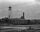
| Date: | 1909 |
|---|---|
| Description: | The site of the Electric Light Plant located near railroad tracks. There is a bell tower with a weather vane on the left. |

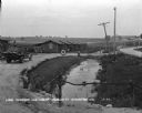
| Date: | 1923 |
|---|---|
| Description: | View down railroad tracks of the McFarland train depot. Two men are on the platform, and a cow grazes in the grass on the left. |

| Date: | 1925 |
|---|---|
| Description: | Elevated view of Mount Vernon from the a grassy hill. |
| Date: | 1930 |
|---|---|
| Description: | View from driveway over a stream towards a row of six log cabins to the left Highway 51. A Texaco Station and a delivery truck are on the far left. Cars ar... |

| Date: | 1911 |
|---|---|
| Description: | View across dirt road of the asylum and grounds. A large three-story building is spread out over several acres. Stairs are leading up to entrances on the s... |

| Date: | |
|---|---|
| Description: | Elevated view of Lake Marion, and the railroad tracks that run along it on the left. A train belching smoke is coming up the tracks. A road runs along the ... |
If you didn't find the material you searched for, our Library Reference Staff can help.
Call our reference desk at 608-264-6535 or email us at:
