 Filter: Categories of Wisconsin Historical Images
Filter: Subject of Roads
Filter: County of Dane
Filter: Creator Name of Unknown
Filter: Categories of Wisconsin Historical Images
Filter: Subject of Roads
Filter: County of Dane
Filter: Creator Name of Unknown
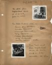
| Date: | 06 19 1940 |
|---|---|
| Description: | First page of the log book of bike hostel trips taken by participants in the Neighborhood House summer program for girls, with images of bicyclists posed b... |
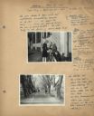
| Date: | 04 25 1941 |
|---|---|
| Description: | Page from the Neighborhood House log book for the first bike hosteling trip of the 1941 season to Sauk City, with three girls securing packs to a bike in f... |
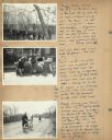
| Date: | 04 25 1941 |
|---|---|
| Description: | Page with more images of the first trip of the 1941 season from the Neighborhood House log book of bike hosteling excursions, with Theresa Manderino, Vince... |

| Date: | 1939 |
|---|---|
| Description: | Page from the Garden Club record book kept by Neighborhood House, with individual pictures of winners of the Best Gardens competition: George Caravello in ... |

| Date: | 1835 |
|---|---|
| Description: | These maps of the towns of Westport, Madison, and Blooming Grove, Dane County, Wisconsin, show sections, roads, trails, lakes and streams, and wetlands fro... |

| Date: | 1854 |
|---|---|
| Description: | This mid-19th century map of Dane County, Wisconsin, shows the township and range grid, towns, sections, cities, villages and post offices, lakes and strea... |

| Date: | 1909 |
|---|---|
| Description: | This 1909 bird's-eye view of Madison and the surrounding Four Lakes region shows roads, railroads, selected buildings in Madison, and points of interest ar... |

| Date: | 1890 |
|---|---|
| Description: | This late-19th century map of Dane County, Wisconsin, shows the township and range grid, towns, sections, cities and villages, lakes and streams, roads, an... |

| Date: | 1914 |
|---|---|
| Description: | Shows lot numbers and dimensions; covers portion of the neighborhood currently known as Shorewood Hills. Includes red annotations showing houses and sold l... |

| Date: | 1970 |
|---|---|
| Description: | Map features a legend of roads, trails, points of interest, buildings, and types of vegetation. To the right are "ARBORETUM REGULATIONS" regarding hours, p... |
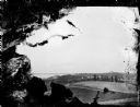
| Date: | |
|---|---|
| Description: | Slightly elevated view over fields of the University of Wisconsin-Madison, showing Bascom Hall, the Observatory, and King Hall from University Heights. Lak... |

| Date: | |
|---|---|
| Description: | An upside down Bancroft delivery truck. A man is standing just behind the front tires. On the right, a "Dane County Police Traffic" car can be seen behind ... |

| Date: | |
|---|---|
| Description: | Three O'Dea sisters and an unidentified man pose while looking out the left side of an automobile. The automobile has a fabric roof but no windows. A dirt ... |

| Date: | 1873 |
|---|---|
| Description: | A map of the township of Primrose from the "Atlas of Dane County." |

| Date: | 1873 |
|---|---|
| Description: | A map of the township of Montrose from the "Atlas of Dane County." |

| Date: | 1861 |
|---|---|
| Description: | The township of Primrose, which is a detail from the plat map of Dane County. |

| Date: | 1861 |
|---|---|
| Description: | The township of Montrose, which is a detail from a Dane County plat map. |

| Date: | |
|---|---|
| Description: | A decorative map of Fuller's Woods development along the Lake Mendota shoreline. Includes numbered lots and building line setbacks with decorative features... |

| Date: | 1911 |
|---|---|
| Description: | A plat map of the township of Westport in Dane County. |
If you didn't find the material you searched for, our Library Reference Staff can help.
Call our reference desk at 608-264-6535 or email us at:
