 Filter: Categories of Wisconsin Historical Images
Filter: Subject of Roads
Filter: County of Dane
Filter: Community of Blue Mounds
Filter: Categories of Wisconsin Historical Images
Filter: Subject of Roads
Filter: County of Dane
Filter: Community of Blue Mounds
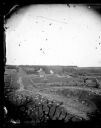
| Date: | 1873 |
|---|---|
| Description: | View down a rocky rural lane near West Blue Mounds. Zigzag stake and rider split-rail fencing enclose a farmstead, which includes a barn, a frame house, ha... |
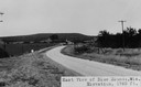
| Date: | |
|---|---|
| Description: | View of rural Blue Mounds, with a two-lane, paved road. The caption at the bottom reads: "East View of Blue Mounds, Wis. Elevation, 1760 ft.". |

| Date: | 07 31 1960 |
|---|---|
| Description: | View of a tree and mailbox, with a farmhouse behind below road level along a rural highway. There is a hill in the background with trees. |

| Date: | 05 30 1964 |
|---|---|
| Description: | Landscape view from field of a rolling countryside. A small cheese factory resides on a slope, with a tree, a windmill, two cars and a tractor near an outb... |
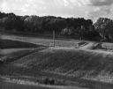
| Date: | 07 1967 |
|---|---|
| Description: | A country road and electrical lines run through a field of oats. On the left is a road, and a farmhouse is in the background on a hill. |

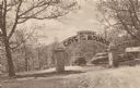
| Date: | 1947 |
|---|---|
| Description: | Colorized postcard of the entrance to the Cave of the Mounds. A curved sign sits on two square stone pillars. The sign reads "Welcome, Cave of the Mounds, ... |
| Date: | |
|---|---|
| Description: | Postcard of the entrance to the Cave of the Mounds. A curved sign sits on two square stone pillars. The sign reads: "Welcome, Cave of the Mounds, Drive In.... |

| Date: | |
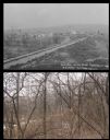
|---|---|
| Description: | View of the village from the railroad tracks. There is a church among the cluster of homes. |

| Date: | 1925 |
|---|---|
| Description: | A view looking up a winding road with rows of utility lines on both sides. The road is partially fenced. |

| Date: | 1867 |
|---|---|
| Description: | This 1867 manuscript map by Increase Lapham shows the topography and geology of the Blue Mounds region in the Town of Brigham in Iowa County and the towns ... |
| Date: | 04 25 2012 |
|---|---|
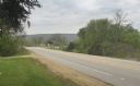
| Description: | A view of the approach to the Village of Blue Mounds from the cemetery. |
| Date: | |
|---|---|
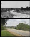
| Description: | A vintage view and a modern view of a road to Blue Mounds, presented as a pair. |
| Date: | |
|---|---|
| Description: | A vintage view and a modern view of the same area in Blue Mounds, presented as a pair. The vintage view shows a road leading into the town. The modern view... |

| Date: | |
|---|---|
| Description: | A vintage view and a modern view of buildings in downtown Blue Mounds, presented as a pair. The buildings house businesses such as restaurants, bars, and a... |
If you didn't find the material you searched for, our Library Reference Staff can help.
Call our reference desk at 608-264-6535 or email us at: