 Filter: Categories of Wisconsin Historical Images
Filter: Subject of Roads
Filter: County of Dane
Filter: Subject of farms
Filter: Categories of Wisconsin Historical Images
Filter: Subject of Roads
Filter: County of Dane
Filter: Subject of farms

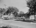
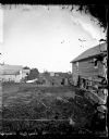
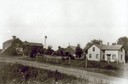
| Date: | 1873 |
|---|---|
| Description: | Main Street, with its dirt, ruts, cows (and presumably manure), but wide enough for easy hitching of wagons and teams. |
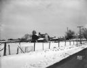
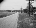
| Date: | 10 03 1960 |
|---|---|
| Description: | Early morning at a railroad crossing on County Highway A, with houses and a barn in the distance. |
| Date: | 09 14 1932 |
|---|---|
| Description: | View across road towards the Bowman dairy and farm on Fish Hatchery Road. |
| Date: | 03 04 1932 |
|---|---|
| Description: | Piper Brothers farm scene, 4718 Odana Road near Midvale. |
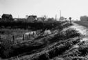
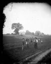
| Date: | 1873 |
|---|---|
| Description: | View of several farms, including Burton's, Fitlen's and Rustebakke's. Field arrangements and fencing patterns are evident. A man is walking along the bott... |
| Date: | |
|---|---|
| Description: | View, looking south of a man wearing a hat in a horse-drawn buggy on a rural lane in Mount Horeb. On the right a man and three children are standing near t... |
| Date: | |
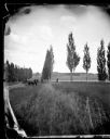
|---|---|
| Description: | View down a poplar-lined lane with fields and fences on the right. A man and child are sitting in the lane in a horse-drawn wagon with a team of two horses... |
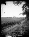
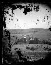
| Date: | 1875 |
|---|---|
| Description: | Elevated view of a man driving a horse-drawn wagon along a rural lane with a man walking in front on the left. In the background is a field, fences, farmho... |
| Date: | |
|---|---|
| Description: | In this tableau, men and boys stand at the edge of the field in elaborate and fanciful poses. The man on the left holds a hoe and cake while the one on the... |

| Date: | 05 10 1928 |
|---|---|
| Description: | The Lutheran Church and buildings, seen from Lutheran Church Hill. |

| Date: | 1955 |
|---|---|
| Description: | Aerial view of Cross Plains, with countryside surrounding and hills on the horizon. |
| Date: | 10 11 1949 |
|---|---|
| Description: | Buckeye Road accident scene, looking north near Homburg farm, 3976 County Trunk Highway AB. |
| Date: | 1912 |
|---|---|
| Description: | Exterior of the Droster farm located on Felland Road. The house was built in 1854. |

| Date: | 11 1928 |
|---|---|
| Description: | Aerial view of Verona including businesses, houses, and the surrounding farm land. |

| Date: | 10 1928 |
|---|---|
| Description: | Aerial view of Sun Prairie, including the central business district, residences, and the surrounding countryside stretching to the horizon. |

| Date: | 11 1928 |
|---|---|
| Description: | Aerial view residential areas of Windsor and the surrounding countryside. |

| Date: | 11 1928 |
|---|---|
| Description: | Aerial view of Black Earth residential area and the surrounding countryside. |

| Date: | 11 1928 |
|---|---|
| Description: | Aerial view of Cross Plains, including residences and the surrounding countryside. |
If you didn't find the material you searched for, our Library Reference Staff can help.
Call our reference desk at 608-264-6535 or email us at:

