 Filter: Categories of Wisconsin Historical Images
Filter: Subject of Roads
Filter: County of Dane
Filter: Subject of human settlements
Filter: Categories of Wisconsin Historical Images
Filter: Subject of Roads
Filter: County of Dane
Filter: Subject of human settlements

| Date: | 06 16 1949 |
|---|---|
| Description: | Freda Winterble property, 901 University Bay Drive, looking north toward Lake Mendota, showing trees on right side of road and house on the left, 928 Unive... |

| Date: | 06 16 1949 |
|---|---|
| Description: | Freda Winterble property, 901 University Bay Drive, looking north toward Lake Mendota, showing large trees on adjoining property. |

| Date: | 1911 |
|---|---|
| Description: | Plat Map of Blooming Grove in "Atlas of Dane County, Wisconsin." |

| Date: | 1938 |
|---|---|
| Description: | The Harold C. Bradley residence at 106 North Prospect Avenue. |

| Date: | 1972 |
|---|---|
| Description: | The Bradley House (Harold and Josephine Crane), at 106 North Prospect Avenue. |
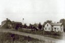
| Date: | 1912 |
|---|---|
| Description: | Exterior of the Droster farm located on Felland Road. The house was built in 1854. |
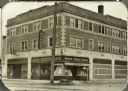
| Date: | 1925 |
|---|---|
| Description: | View from street of new Rennebohm Drug Store #1 at 1357 University Avenue at the corner of Randall Avenue, shortly after its construction. |

| Date: | 1955 |
|---|---|
| Description: | Aerial view of the central traffic loop and Johnson Street expressway. |

| Date: | 1955 |
|---|---|
| Description: | Aerial view of the Illinois central route. The UW Fieldhouse is visible in the lower right of the image. |
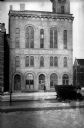
| Date: | 1920 |
|---|---|
| Description: | City Hall. 2 West Mifflin Street, with large "Welcome" sign across the front. It was built in the Romanesque style by Donnell and Kutzbock. |
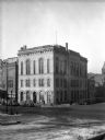
| Date: | 1920 |
|---|---|
| Description: | Madison City Hall, 2 West Mifflin Street, built in 1857, originally had a small Romanesque clock tower in the corner closest to the camera in this photogra... |
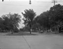
| Date: | 06 21 1948 |
|---|---|
| Description: | East Washington Avenue at First Street showing the trees lining the boulevard and the sides of the street. Residents are protesting the proposed removal of... |
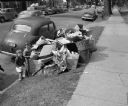
| Date: | 06 15 1948 |
|---|---|
| Description: | Uncollected garbage on South Hamilton Street being viewed by two children during a walkout strike by Local 236 Municipal Garage Department Union. |
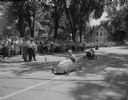
| Date: | 07 26 1947 |
|---|---|
| Description: | Crowd and officials watch Soap Box Derby contestants at the finish line on East Gorham Street. |

| Date: | 1955 |
|---|---|
| Description: | Elevated view of Capitol Square, looking northwest up Carroll Street at its intersection with Main Street. |

| Date: | 11 1928 |
|---|---|
| Description: | Aerial view of Verona including businesses, houses, and the surrounding farm land. |

| Date: | 10 1928 |
|---|---|
| Description: | Aerial view of Sun Prairie, including the central business district, residences, and the surrounding countryside stretching to the horizon. |

| Date: | 11 1928 |
|---|---|
| Description: | Aerial view of Stoughton, including the central business district, residential areas, the Yahara River, and the surrounding countryside. |

| Date: | 11 1928 |
|---|---|
| Description: | Aerial view residential areas of Windsor and the surrounding countryside. |

| Date: | 11 1928 |
|---|---|
| Description: | Aerial view of Black Earth residential area and the surrounding countryside. |
If you didn't find the material you searched for, our Library Reference Staff can help.
Call our reference desk at 608-264-6535 or email us at: