Filter: Categories of Wisconsin Historical Images
Filter: Subject of Roads
Filter: County of Dane
Filter: Subject of land use, rural
Filter: Categories of Wisconsin Historical Images
Filter: Subject of Roads
Filter: County of Dane
Filter: Subject of land use, rural

| Date: | 1873 |
|---|---|
| Description: | Main Street, with its dirt, ruts, cows (and presumably manure), but wide enough for easy hitching of wagons and teams. |
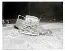
| Date: | 04 15 1934 |
|---|---|
| Description: | Onlookers surveying damage from a fatal two-car collision. The view is looking south on County Trunk Highway M, between Speedway Road and Middleton. In the... |
| Date: | 08 18 1939 |
|---|---|
| Description: | View from front of Capital City Culvert Company automobile involved in an accident with a Phillips Produce Company egg truck at the intersection of County ... |
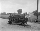
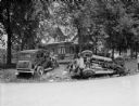
| Date: | 06 12 1932 |
|---|---|
| Description: | Car accident on County Trunk K that killed four members of the Price family. The scene was photographed for the Dane County coroner Campbell. |

| Date: | 1910 |
|---|---|
| Description: | Map of Dane County rural delivery in Madison and the town of Westport. |

| Date: | 12 01 1962 |
|---|---|
| Description: | A farm road between fields in late sunlight, looking towards Mounds Creek in the vicinity of CTH F. |
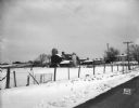
| Date: | 10 03 1960 |
|---|---|
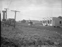
| Description: | Early morning at a railroad crossing on County Highway A, with houses and a barn in the distance. |
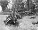
| Date: | 06 12 1932 |
|---|---|
| Description: | View across road towards a car crash, with two vehicles on the side of the road. Taken for the coroner at the scene of an accident in Token Creek. Four Pri... |
| Date: | 03 04 1932 |
|---|---|
| Description: | Piper Brothers farm scene, 4718 Odana Road near Midvale. |
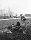
| Date: | 11 12 1931 |
|---|---|
| Description: | Boy Scouts planting a Norway spruce tree on "George Washington Drive," a stretch of road a mile long on Highway 51, extending north from the intersection w... |
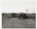
| Date: | 10 20 1931 |
|---|---|
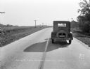
| Description: | View looking down road (east-south east) towards the rear of a car parked in the right lane of a two lane highway. This was the scene of an accident, and i... |
| Date: | 10 20 1931 |
|---|---|
| Description: | Accident scene on Highway 51, rural area. Caption at bottom reads: "High #51 — Looking West — Northwest — October 20, 1931 2:00 P.M." |
| Date: | 08 10 1931 |
|---|---|
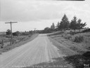
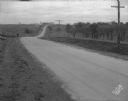
| Description: | County Highway G, Mount Vernon, looking south, taken for Travelers Insurance Co. Dane County. |
| Date: | 06 30 1931 |
|---|---|
| Description: | Ray's Barbecue and Standard Oil Gas Station, on the Oregon Road (just beyond the French Village which was located at 2323 S. Park Street). |
| Date: | 11 08 1928 |
|---|---|
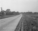
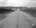
| Description: | Stretch of paved rural highway featuring a proprietary centerline joint, looking towards Mount Horeb from the east. |
| Date: | 11 08 1928 |
|---|---|
| Description: | Stretch of paved rural highway near Mount Horeb featuring a proprietary centerline joint. |
| Date: | 1875 |
|---|---|
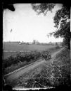
| Description: | Elevated view of a man driving a horse-drawn wagon along a rural lane with a man walking in front on the left. In the background is a field, fences, farmho... |

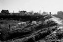
| Date: | 1873 |
|---|---|
| Description: | View, from a distance, of Middleton. The view includes A.L. Dahl's horse-drawn wagon. |
| Date: | |
|---|---|
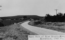
| Description: | View of rural Blue Mounds, with a two-lane, paved road. The caption at the bottom reads: "East View of Blue Mounds, Wis. Elevation, 1760 ft.". |
If you didn't find the material you searched for, our Library Reference Staff can help.
Call our reference desk at 608-264-6535 or email us at: