 Filter: Categories of Wisconsin Historical Images
Filter: Subject of Roads
Filter: County of Dane
Filter: Subject of trails
Filter: Categories of Wisconsin Historical Images
Filter: Subject of Roads
Filter: County of Dane
Filter: Subject of trails
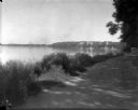
| Date: | 1926 |
|---|---|
| Description: | Lake Mendota, including Fraternity Row and east side shoreline, taken from the lake path on University Bay Drive. |

| Date: | 1923 |
|---|---|
| Description: | Aerial view of the Wisconsin Historical Society, Science Hall, and Bascom Hall on Bascom Hill on the University of Wisconsin-Madison campus. Lake Mendota i... |
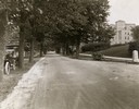
| Date: | 1922 |
|---|---|
| Description: | View of tree-lined Linden Drive includes parked motorcycles and automobiles on the University of Wisconsin campus. |

| Date: | 1907 |
|---|---|
| Description: | Elevated view looking northeast from the chimney of the Power Plant on University Avenue. The Chemistry Building is in the foreground, and Bascom Hall and ... |

| Date: | 08 17 1927 |
|---|---|
| Description: | Elevated view of dormitories on the University of Wisconsin-Madison campus. Adams, Van Hise and Tripp Halls with Lake Mendota in the background. Picnic Poi... |

| Date: | 1907 |
|---|---|
| Description: | Elevated view looking northeast from the chimney of the Power Plant on University Avenue. The Chemistry Building is in the foreground, and Bascom Hall and ... |

| Date: | 1909 |
|---|---|
| Description: | Elevated view over University Avenue towards the northeast of Bascom Hall and Lake Mendota on the University of Wisconsin-Madison campus. The Chemistry Bui... |
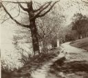
| Date: | 1896 |
|---|---|
| Description: | Looking down University of Wisconsin Drive (present-day Lakeshore Path). Large trees grows along the shoreline on the left, and on the right is a thick woo... |

| Date: | 1974 |
|---|---|
| Description: | This 1974 map is a reproduction of the original survey maps of the Four Lakes region of Dane County, Wisconsin. It shows sections, lakes, rivers, wetlands,... |

| Date: | 1836 |
|---|---|
| Description: | Map shows rivers, creeks, roads, trails, mills, and town of Madison. Includes significant manuscript annotations; Sheet 1 is watercolor on lithographed map... |

| Date: | 1970 |
|---|---|
| Description: | Map features a legend of roads, trails, points of interest, buildings, and types of vegetation. To the right are "ARBORETUM REGULATIONS" regarding hours, p... |

| Date: | 1928 |
|---|---|
| Description: | This map shows the Forest Hill Cemetery and is oriented with the north to the lower left. The map shows buildings and section numbers but does not include ... |

| Date: | |
|---|---|
| Description: | View down the Yahara River towards where it enters Lake Monona at Yahara Park. There are a few houses on either side of the river. Caption reads: "Yahara R... |
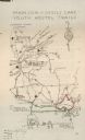
| Date: | 06 1938 |
|---|---|
| Description: | Map showing major highways and trails from Madison to Devil's Lake for Neighborhood House American Youth Hostel group trips. Routes of four trips are drawn... |
If you didn't find the material you searched for, our Library Reference Staff can help.
Call our reference desk at 608-264-6535 or email us at:
