Filter: Categories of Wisconsin Historical Images
Filter: Subject of Roads
Filter: County of Dane
Filter: Year of 1800-1899
Filter: Categories of Wisconsin Historical Images
Filter: Subject of Roads
Filter: County of Dane
Filter: Year of 1800-1899
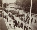
| Date: | 1894 |
|---|---|
| Description: | An elevated view of a Decoration Day parade, near what appears to be Capitol Park. A small crowd gathers at the edge of the street to view a military band ... |
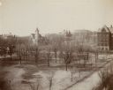
| Date: | 1897 |
|---|---|
| Description: | Elevated view over Langdon Street of the University of Wisconsin-Madison campus. South Hall, Music Hall, and Science Hall are visible. Bascom Hill and a ce... |
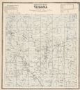
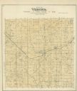
| Date: | 1873 |
|---|---|
| Description: | A map of Verona Township from the Dane County Atlas. |

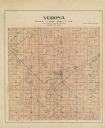
| Date: | 1890 |
|---|---|
| Description: | A plat map of a portion of Verona in Dane County. |
| Date: | 07 04 1876 |
|---|---|
| Description: | Two men stand by a wagon on which is written "A.L. Dahl Landscape Photographer." The photographer stands on the left side of the view. The flag on the side... |

| Date: | 1844 |
|---|---|
| Description: | Part of a series of local maps, showing a number of burial mounds in the shape of animals near Madison, Wisconsin along military road. The maps also show d... |

| Date: | 1835 |
|---|---|
| Description: | These maps of the towns of Westport, Madison, and Blooming Grove, Dane County, Wisconsin, show sections, roads, trails, lakes and streams, and wetlands fro... |

| Date: | 1854 |
|---|---|
| Description: | This mid-19th century map of Dane County, Wisconsin, shows the township and range grid, towns, sections, cities, villages and post offices, lakes and strea... |

| Date: | 1890 |
|---|---|
| Description: | This late-19th century map of Dane County, Wisconsin, shows the township and range grid, towns, sections, cities and villages, lakes and streams, roads, an... |

| Date: | 1867 |
|---|---|
| Description: | This 1867 manuscript map by Increase Lapham shows the topography and geology of the Blue Mounds region in the Town of Brigham in Iowa County and the towns ... |

| Date: | 1836 |
|---|---|
| Description: | Map shows rivers, creeks, roads, trails, mills, and town of Madison. Includes significant manuscript annotations; Sheet 1 is watercolor on lithographed map... |
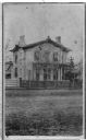
| Date: | 1866 |
|---|---|
| Description: | Carte-de-visite of local merchant Thaddeus Dean's residence, located at the intersection of Wisconsin Avenue and Gorham Street. |
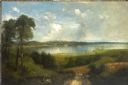
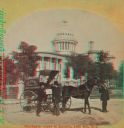
| Date: | 1884 |
|---|---|
| Description: | Sunrise over Lake Monona and the Madison, Wisconsin isthmus, showing the Wisconsin State Capitol building in the distance. |

| Date: | 1873 |
|---|---|
| Description: | A map of the township of Primrose from the "Atlas of Dane County." |

| Date: | 1873 |
|---|---|
| Description: | A map of the township of Montrose from the "Atlas of Dane County." |

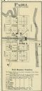
| Date: | 1861 |
|---|---|
| Description: | The township of Primrose, which is a detail from the plat map of Dane County. |
If you didn't find the material you searched for, our Library Reference Staff can help.
Call our reference desk at 608-264-6535 or email us at: