Filter: Categories of Wisconsin Historical Images
Filter: Subject of Roads
Filter: County of Dane
Filter: Year of 1800-1899
Filter: Categories of Wisconsin Historical Images
Filter: Subject of Roads
Filter: County of Dane
Filter: Year of 1800-1899

| Date: | 1861 |
|---|---|
| Description: | The township of Montrose, which is a detail from a Dane County plat map. |

| Date: | 1885 |
|---|---|
| Description: | A detail of a Sanborn map including Catfish Creek and Westport Road by Lake Mendota. |

| Date: | 1871 |
|---|---|
| Description: | This map shows buildings, roads, the railroad, an orchard, and swamp land. Relief shown by hachures. The map includes an index of buildings in the upper ri... |

| Date: | 04 03 1896 |
|---|---|
| Description: | View down dirt road towards Madison from Elmside. There is a horse and buggy on the side of the road near the shoreline, with a woman wearing a veil sittin... |

| Date: | 1898 |
|---|---|
| Description: | This manuscript blueprint map covers property along Winnequah Road in area now part of Monona, Wisconsin. Lake Monona is labeled to the left and posts are ... |

| Date: | 1880 |
|---|---|
| Description: | This blueprint map shows proposed railroad tracks between Carroll Street and Wisconsin Avenue along Lake Monona. |

| Date: | 1885 |
|---|---|
| Description: | View along shoreline towards Tonyawatha House and several outbuildings on Lake Monona. There is a long dock extending into the lake from a boathouse on the... |

| Date: | 1850 |
|---|---|
| Description: | A grist mill on the Yahara River at the outlet of Lake Mendota. The mill, called Farwell's Madison Mills was built in 1850 by Governor Farwell. The origina... |

| Date: | 1899 |
|---|---|
| Description: | A plat map of Pleasant Springs in Dane County. |
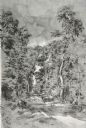
| Date: | 1852 |
|---|---|
| Description: | View down a road lined with trees. Two people in a horse-drawn vehicle are moving down the road. Caption reads: "Unidientified road in the vicinity of Madi... |

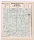
| Date: | 1899 |
|---|---|
| Description: | A plat map of the township of Christiana. |
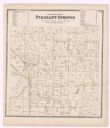
| Date: | 1873 |
|---|---|
| Description: | A plat map of the town of Pleasant Springs. |
If you didn't find the material you searched for, our Library Reference Staff can help.
Call our reference desk at 608-264-6535 or email us at: