 Filter: Categories of Wisconsin Historical Images
Filter: Subject of Roads
Filter: County of Dane
Filter: Year of 1900-1999
Filter: Type of Map or Atlas
Filter: Categories of Wisconsin Historical Images
Filter: Subject of Roads
Filter: County of Dane
Filter: Year of 1900-1999
Filter: Type of Map or Atlas

| Date: | 1910 |
|---|---|
| Description: | Map of Dane County rural delivery in Madison and the town of Westport. |

| Date: | 1949 |
|---|---|
| Description: | Color bird's-eye map of the University of Wisconsin-Madison as it was midcentury, with two co-eds, several photographs of campus landmarks around edges, an... |

| Date: | 1911 |
|---|---|
| Description: | Plat Map of Blooming Grove in "Atlas of Dane County, Wisconsin." |

| Date: | 1904 |
|---|---|
| Description: | This map shows a plat of the east part of the city, numbered blocks and lots, some landownership, local streets, roads, railroads, wards by number, parks, ... |

| Date: | 1904 |
|---|---|
| Description: | This map shows a plat of the west part of the city, numbered blocks and lots, some landownership, local streets, roads, railroads, wards by number, parks, ... |

| Date: | 1959 |
|---|---|
| Description: | University of Wisconsin-Madison campus. Numbers in circles identify buildings across campus with the building index. Black arrows point out important infor... |
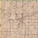
| Date: | 1914 |
|---|---|
| Description: | The Verona township, a detail of the Dane County, Wisconsin map of land ownership. |
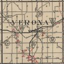
| Date: | 1904 |
|---|---|
| Description: | A map of Verona, which is a detail from a map of Dane County, Wisconsin. |

| Date: | 1911 |
|---|---|
| Description: | A map of the village of Black Earth and Verona. |

| Date: | 1926 |
|---|---|
| Description: | A plat map of the village of Verona in Dane County. |
| Date: | 1924 |
|---|---|
| Description: | Map of Verona in Dane County from the Charles Brown Atlas. |

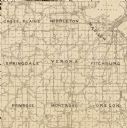
| Date: | 1920 |
|---|---|
| Description: | Detail of a map of Dane county showing only Verona. |
If you didn't find the material you searched for, our Library Reference Staff can help.
Call our reference desk at 608-264-6535 or email us at:


