 Filter: Categories of Wisconsin Historical Images
Filter: Subject of Roads
Filter: County of Dane
Filter: Categories of Wisconsin Historical Images
Filter: Subject of Roads
Filter: County of Dane

| Date: | 1955 |
|---|---|
| Description: | Elevated view of Capitol Square, looking northwest up Carroll Street at its intersection with Main Street. |

| Date: | 11 1928 |
|---|---|
| Description: | Aerial view of Verona including businesses, houses, and the surrounding farm land. |

| Date: | 10 1928 |
|---|---|
| Description: | Aerial view of Sun Prairie, including the central business district, residences, and the surrounding countryside stretching to the horizon. |

| Date: | 11 1928 |
|---|---|
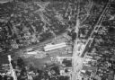
| Description: | Aerial view of Stoughton, including the central business district, residential areas, the Yahara River, and the surrounding countryside. |

| Date: | 11 1928 |
|---|---|
| Description: | Aerial view residential areas of Windsor and the surrounding countryside. |

| Date: | 11 1928 |
|---|---|
| Description: | Aerial view of Black Earth residential area and the surrounding countryside. |

| Date: | 11 1928 |
|---|---|
| Description: | Aerial view of Cross Plains, including residences and the surrounding countryside. |
| Date: | 1935 |
|---|---|
| Description: | Aerial view of the French Battery Company facility, East Washington Avenue, and Winnebago Street at the Union Corners intersection. |
| Date: | 1955 |
|---|---|
| Description: | West Doty Street, from Monona Avenue looking toward South Carroll Street, showing the back side of Madison Newspapers, Inc. The building was added on to in... |

| Date: | 02 08 1970 |
|---|---|
| Description: | Chicago, Milwaukee, St. Paul & Pacific Railroad tracks running down the middle of East Wilson Street from South Baldwin Street to Dickinson Street. |
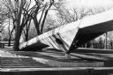
| Date: | 03 15 1970 |
|---|---|
| Description: | The skywalk on the University of Wisconsin-Madison campus that reaches across Park Street from Bascom Hill to the UW Humanities building. |
| Date: | 1935 |
|---|---|
| Description: | View of Regent Street from the intersection of Regent and Monroe Streets. |

| Date: | 01 31 1971 |
|---|---|
| Description: | A majestic brick building which housed the Teckmeyer Candy Company, the Globe Bakery, and the original Buy-and-Sell Shop before the State of Wisconsin took... |

| Date: | 02 07 1971 |
|---|---|
| Description: | Exterior view of St. Patrick's Catholic Church at 410 East Main Street which was dedicated on March 17, 1889. The church was designed by T.C. McCarthy and ... |

| Date: | 10 10 1971 |
|---|---|
| Description: | Two houses at 1112 and 1114 Regent Street, both of which lean to one side. |
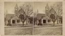
| Date: | 1886 |
|---|---|
| Description: | Stereograph of the First Unitarian Church, which stood on Wisconsin Avenue near the Post Office. |

| Date: | 07 26 1970 |
|---|---|
| Description: | Exterior view of the First Lutheran Kirch on Old Sauk Road, which was used by the Bethel Baptist congregation after 100 years as a Lutheran church. |
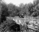
| Date: | 1901 |
|---|---|
| Description: | A.G. Zimmerman parked on an artfully rustic, wooden bridge in his automobile, a "locomobile steamer," on Mendota Drive. |
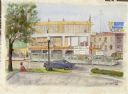
| Date: | 1952 |
|---|---|
| Description: | Watercolor painting of a Wolff-Kubly & Hirsig building (the site of the current Wisconsin Historical Museum) under construction. |
If you didn't find the material you searched for, our Library Reference Staff can help.
Call our reference desk at 608-264-6535 or email us at:
