 Filter: Categories of Wisconsin Historical Images
Filter: Subject of Roads
Filter: Subject of botany
Filter: Categories of Wisconsin Historical Images
Filter: Subject of Roads
Filter: Subject of botany

| Date: | 1867 |
|---|---|
| Description: | Birds eye drawing of Fond du Lac depicts street names and street layouts, houses, buildings, trees, and the Fond du Lac River. A reference key at the botto... |

| Date: | 1886 |
|---|---|
| Description: | Bird's-eye map of Hurley with insets Mining at the Colby, Hurley in 1885, and North Front of Silver Street. |

| Date: | 1870 |
|---|---|
| Description: | Although the first European settlement in Jefferson was in 1836, the Village of Jefferson was first incorporated as a city in 1878. Made eight years earlie... |

| Date: | 1867 |
|---|---|
| Description: | Bird's-eye map of La Crosse with nine insets of residences, schools, and the Court House and Jail. |
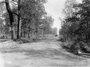
| Date: | 12 03 1915 |
|---|---|
| Description: | Car coming down a rural dirt road. Caption reads: "A view on Houston and Oklona Pike. Chickasaw Co. has over 100 miles of fine pikes and building more." A ... |
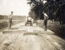
| Date: | 1915 |
|---|---|
| Description: | Road workers grading a rural country road with an Avery tractor and wooden grading blocks. The image was cropped from a postcard collected by International... |
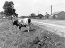
| Date: | 08 1929 |
|---|---|
| Description: | Bull standing along a rural road with farm buildings in the background. Original caption reads: "Better tether him out than for him not to get pasture." |

| Date: | 1852 |
|---|---|
| Description: | Pencil drawing of Madison landscape as seen from University Hill. The main street in the center is State Street, and the building with Greek columns in the... |
| Date: | 1859 |
|---|---|
| Description: | Daguerreotype of elevated view of Pinckney Street, looking northwest. View includes the American House and Bruen's Block, both on the corner of East Washin... |

| Date: | 1882 |
|---|---|
| Description: | Bird's-eye views of various sections of Milwaukee. |

| Date: | 1885 |
|---|---|
| Description: | Bird's-eye map of Oconomowoc. |

| Date: | 1870 |
|---|---|
| Description: | Bird's-eye map of Prairie du Sac. |
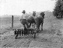
| Date: | 06 12 1919 |
|---|---|
| Description: | Farmer riding down a dirt path on a horse-drawn McCormick disc harrow on transport wheels. |

| Date: | 1882 |
|---|---|
| Description: | Bird's-eye map of Lake Geneva, looking southwest, with insets of points of interest. |

| Date: | 1886 |
|---|---|
| Description: | Bird's-eye map of Menomonee Falls. |

| Date: | 1870 |
|---|---|
| Description: | Sauk City is the oldest incorporated village in Wisconsin (incorporated in 1854) and also has the oldest organized volunteer fire department in the state, ... |

| Date: | 1883 |
|---|---|
| Description: | Bird's-eye map of Superior, county seat of Douglas County, on the shores of Lake Superior, with insets of points of interest. |

| Date: | 1857 |
|---|---|
| Description: | Elevated view of Waukesha with two women wearing dresses with a boy in long pants and tam o'shanter hat in foreground against a split-rail fence. Beyond th... |

| Date: | 1880 |
|---|---|
| Description: | Bird's-eye map of Waukesha, county seat of Waukesha County. |
If you didn't find the material you searched for, our Library Reference Staff can help.
Call our reference desk at 608-264-6535 or email us at:
