 Filter: Categories of Wisconsin Historical Images
Filter: Subject of Schools
Filter: County of Ashland
Filter: Categories of Wisconsin Historical Images
Filter: Subject of Schools
Filter: County of Ashland
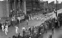
| Date: | 1935 |
|---|---|
| Description: | Elevated view of students in a school marching band in a parade marching down Main Street. Students are wearing uniforms and are playing instruments includ... |
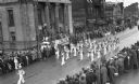
| Date: | 1937 |
|---|---|
| Description: | Elevated view of students in a school marching band in a parade marching down Main Street. Students are wearing marching band uniforms and are playing inst... |

| Date: | 1935 |
|---|---|
| Description: | Elevated view of students in a school marching band in a parade marching down Main Street. Students are wearing marching band uniforms and are playing inst... |
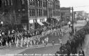
| Date: | 1939 |
|---|---|
| Description: | Elevated view of students from the Grade School Rhythm Band at the Music Festival, marching down Main Street. Students are wearing light or white clothing ... |
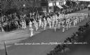
| Date: | 1939 |
|---|---|
| Description: | Elevated view of students from the Ashland Grade School Rhythm Band at the Music Festival, marching down Main Street. The students are wearing light unifor... |

| Date: | 1939 |
|---|---|
| Description: | This map shows the towns to Gingles, Sanborn, and Guney as well as Chequamegon Bay, Kakagon River, White River, Marengo River, Bad River, Potato River, Vau... |

| Date: | 1978 |
|---|---|
| Description: | Teacher Dorothy Ledin teaching numbers to two pre-schoolers using a board with removable numbers and dots at Ellis School. |

| Date: | 1978 |
|---|---|
| Description: | Congressman David R. Obey of Wisconsin (center) holding a press conference about federal funding for education with students at Ellis School. A few journal... |

| Date: | 1887 |
|---|---|
| Description: | This 1887 map of Ashland County, Wisconsin, shows the township and range system, sections, railroads, vacant Wisconsin Central Railroad land, state and "go... |

| Date: | 1896 |
|---|---|
| Description: | This 1896 map shows the township and range system, sections, cities and villages, railroads, roads, vacant land and land sold by the Wisconsin Central Rail... |

| Date: | 1900 |
|---|---|
| Description: | This map is shows land in white and water in blue and is indexed for parks, points of interest, schools, churches, and recreational areas. The map shows lo... |

| Date: | 1915 |
|---|---|
| Description: | This map shows school houses, churches, farms, and railroads. Chequamecon Bay and Bad River Indian Reservation are labeld. The map reads: "All lands shown ... |
If you didn't find the material you searched for, our Library Reference Staff can help.
Call our reference desk at 608-264-6535 or email us at:
