Filter: Categories of Wisconsin Historical Images
Filter: Subject of Schools
Filter: County of La Crosse
Filter: Categories of Wisconsin Historical Images
Filter: Subject of Schools
Filter: County of La Crosse

| Date: | 1867 |
|---|---|
| Description: | Bird's-eye map of La Crosse with nine insets of residences, schools, and the Court House and Jail. |
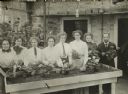
| Date: | 1911 |
|---|---|
| Description: | Group of women from the District Agricultural School, and gardener E.E. Harris on the far right. They are standing in a row potting plants at a potting tab... |
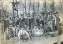
| Date: | 1911 |
|---|---|
| Description: | Group of boys outdoors with gardener E.E. Harris. Original caption reads: "Boys of the Onalaska Agricultural School, with rakes and forks, saws and other i... |
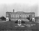
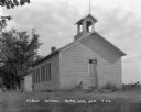
| Date: | 1926 |
|---|---|
| Description: | Exterior view of the Mindoro high school and grade school, housed in the same two-story, brick building. A plaque in front of the school commemorates Farmi... |

| Date: | 1954 |
|---|---|
| Description: | This map of La Crosse shows residential, multiple dwelling, local business, commercial, light industrial, heavy industrial and special multiple dwelling la... |

| Date: | 1859 |
|---|---|
| Description: | This map show plats including plat names, plat numbers, and some lot owner's names. Relief is shown by hachures. The map includes line drawings of Juneau B... |

| Date: | 1886 |
|---|---|
| Description: | This map has relief shown by hachures and includes a list of plats in order of date of record, laws which vacate plats, plats not shown as upon the county ... |

| Date: | 1888 |
|---|---|
| Description: | This map has relief shown by hachures and features inset maps of a plat of E.D. Clinton and Blackwell’s add’n to the City of La Crosse. Wards (1-10) shaded... |

| Date: | 1927 |
|---|---|
| Description: | This map includes an index and highways marked in red. Attractions on the map include: Four Mile House, Cold Springs, Grand Crossing Station, Coleman Sloug... |

| Date: | 1889 |
|---|---|
| Description: | This map lists township and section numbers outside municipality, housing additions and subdivisions and plat owners outside municipality, the Black River,... |
If you didn't find the material you searched for, our Library Reference Staff can help.
Call our reference desk at 608-264-6535 or email us at: