Filter: Categories of Wisconsin Historical Images
Filter: Subject of Schools
Filter: County of Marathon
Filter: Categories of Wisconsin Historical Images
Filter: Subject of Schools
Filter: County of Marathon

| Date: | 1891 |
|---|---|
| Description: | Bird's-eye map of Wausau, looking north with ninety-eight businesses, industries, churches, schools, and civic buildings identified in location key below i... |

| Date: | 1879 |
|---|---|
| Description: | This map is a bird's-eye view of Wausau, the County Seat of Marathon County. The map features an index of points of interest. |

| Date: | 05 02 1964 |
|---|---|
| Description: | Sitting on the school lawn, students draw Highway 51, Marathon Mill, Rib mountain and the Wisconsin River. |
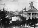
| Date: | 1890 |
|---|---|
| Description: | Elevated view. The church in the left background is the Zion Lutheran Church. The white house behind the bandstand is Captain Leahy's home (father of Admir... |
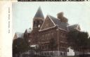
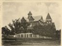
| Date: | 1905 |
|---|---|
| Description: | View toward the front and left side of the school. Caption reads: "Lincoln School, Wausau, Wis." |
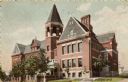
| Date: | 1907 |
|---|---|
| Description: | View toward the front and right side of the school. Caption reads: "Lincoln School, Wausau, Wis." |

| Date: | 1901 |
|---|---|
| Description: | A plat map of Marathon county, township 29, north range, 6 east. |
If you didn't find the material you searched for, our Library Reference Staff can help.
Call our reference desk at 608-264-6535 or email us at: