 Filter: Categories of Wisconsin Historical Images
Filter: Subject of Schools
Filter: County of Outagamie
Filter: Categories of Wisconsin Historical Images
Filter: Subject of Schools
Filter: County of Outagamie
| Date: | |
|---|---|
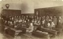
| Description: | School group in classroom with teacher, possibly at Appleton, Wisconsin. |

| Date: | 1903 |
|---|---|
| Description: | This 1903 map of Outagamie County, Wisconsin, shows the township and range grid, towns, sections, cities and villages, landownership and acreages, rural ma... |

| Date: | |
|---|---|
| Description: | This 1907 map of Outagamie County, Wisconsin, shows the township and range grid, towns, sections, cities and villages, railroads, wagon roads, churches, sc... |

| Date: | 1922 |
|---|---|
| Description: | This map of Outagamie County, Wisconsin, from the first half of the 20th century, shows the township and range grid, towns, sections, cities and villages, ... |
| Date: | |
|---|---|
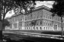
| Description: | Exterior view of Appleton High School. Caption reads: "High School - Appleton, Wis." |
| Date: | 1904 |
|---|---|
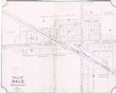
| Description: | This map shows land parcels, street names, and school locations, and potential land additions to the town. The Wisconsin Central Railroad is labeled. |
If you didn't find the material you searched for, our Library Reference Staff can help.
Call our reference desk at 608-264-6535 or email us at: