 Filter: Categories of Wisconsin Historical Images
Filter: Subject of Schools
Filter: County of Sheboygan
Filter: Categories of Wisconsin Historical Images
Filter: Subject of Schools
Filter: County of Sheboygan
| Date: | |
|---|---|
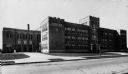
| Description: | View across street towards the South Side Junior High School in Sheboygan. |
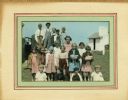
| Date: | 1932 |
|---|---|
| Description: | Hand-colored photograph of students from Liberty school, a one-room school in Sheboygan County. The children in the back row are standing on the bumper of ... |
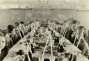
| Date: | 11 26 1930 |
|---|---|
| Description: | Students and teacher seated at a long table loaded with food and drinks for a Thanksgiving meal. There are music and English lessons behind them on the cha... |

| Date: | 1862 |
|---|---|
| Description: | This 1862 map of Sheboygan County, Wisconsin, shows land ownership and acreages, the township and range grid, towns, cities and villages, roads, railroads,... |

| Date: | 1906 |
|---|---|
| Description: | This map of Sheboygan County, Wisconsin, from the early 20th century shows school districts and school locations in the county. Also shown are the township... |
If you didn't find the material you searched for, our Library Reference Staff can help.
Call our reference desk at 608-264-6535 or email us at:
