 Filter: Categories of Wisconsin Historical Images
Filter: Subject of Schools
Filter: Subject of economics
Filter: Categories of Wisconsin Historical Images
Filter: Subject of Schools
Filter: Subject of economics

| Date: | 1919 |
|---|---|
| Description: | Advertising poster advertising a free tractor school sponsored by the International Harvester Company. Includes a black and white illustration of a Titan 1... |

| Date: | 1890 |
|---|---|
| Description: | Bird's-eye map of Beloit with insets of Williams Engine Works, Eclipse Wind Engine Co., and John Foster & Co. Turtle Creek is in the lower section, and the... |

| Date: | |
|---|---|
| Description: | Eleven portraits of young costumed students appear in an advertisement reading "Leo Kehl Dancers To Appear In Recital." |

| Date: | 09 24 1944 |
|---|---|
| Description: | Children participating in a thimble party at the Shorewood Hills School while their mothers participated in the annual Madison Woman's Club benefit party. ... |
| Date: | 06 28 1945 |
|---|---|
| Description: | Advertisement, which originally appeared in "The New Masses," June 26, 1945, and was reproduced in the "Wisconsin State Journal," for the Abraham Lincoln S... |

| Date: | 01 10 1948 |
|---|---|
| Description: | Loretta Nelson, a commercial student, practicing on a bookkeeping machine at Madison Vocational and Adult Education School, 211-213 North Carroll Street. |

| Date: | 03 01 1948 |
|---|---|
| Description: | Harry M. Hanson, Dane County superintendent of schools, eastern district (left), is shown as he turned over $1,075.50 to Mayor James R. Law, Dane County Ma... |

| Date: | |
|---|---|
| Description: | Unemployed men on a street with the word "Unemployment" collaged above. Part of a series of Highlander collages from the film center. |

| Date: | 1913 |
|---|---|
| Description: | A wall atlas of Sauk County, Wisconsin, displaying its 22 towns. On the left side are advertisements for local businesses. |

| Date: | 1940 |
|---|---|
| Description: | Flyer titled In Wisconsin, School Costs Are the Heaviest Burden on General Property Taxpayers published by the League of Wisconsin Municipalities wi... |
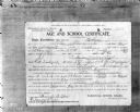
| Date: | 01 05 1907 |
|---|---|
| Description: | Photograph of an "Age and School Certificate" completed by a mother giving her 15-year-old son permission to work. The form reads: "THIS CERTIFICATE NOT T... |

| Date: | 1895 |
|---|---|
| Description: | The front (left) and back (right) of a promotional card advertising farming land in northern Wisconsin. The caption below the image reads: "A typical cou... |

| Date: | 1877 |
|---|---|
| Description: | A map of Monroe County, Wisconsin that shows the townships and landownership and acreage wagon roads, railroads, streams, schools, and houses. Also include... |

| Date: | |
|---|---|
| Description: | This map from the early 20th century shows the township and range grid, towns, sections, cities and villages, railroads, roads, schools, churches, and stre... |

| Date: | 1903 |
|---|---|
| Description: | This map of Richland County, Wisconsin, shows land ownership and acreages, the township and range grid, sections, cities, towns and post offices, roads, ra... |

| Date: | 1876 |
|---|---|
| Description: | This 1876 map of Saint Croix County, Wisconsin, shows the township and range grid, sections, towns, cities and villages, land ownership and acreages, wagon... |

| Date: | 1877 |
|---|---|
| Description: | This 1877 map of Trempealeau County, Wisconsin, shows the township and range grid, sections, towns, cities and villages, land ownership and acreages, roads... |

| Date: | 1878 |
|---|---|
| Description: | This 1878 map of Vernon County, Wisconsin, shows the township and range grid, sections, towns, cities and villages, land ownership and acreages, roads, rai... |

| Date: | 1896 |
|---|---|
| Description: | This late 19th-century map of Dodge County, Wisconsin, shows the township and range grid, towns, sections, cities, villages and post offices, some property... |

| Date: | 1932 |
|---|---|
| Description: | This map of Granville shows streets, businesses, residential areas, schools, golf courses, and industrial areas. The map shows Granville in March of 1932. ... |
If you didn't find the material you searched for, our Library Reference Staff can help.
Call our reference desk at 608-264-6535 or email us at: