 Filter: Categories of Wisconsin Historical Images
Filter: Subject of Schools
Filter: Subject of food industry and trade
Filter: Categories of Wisconsin Historical Images
Filter: Subject of Schools
Filter: Subject of food industry and trade

| Date: | 1880 |
|---|---|
| Description: | Bird's-eye map over the Mississippi River of Fountain City. Paddle steamers and steamboats are on the river, and bluffs are in the background. |

| Date: | 12 18 1963 |
|---|---|
| Description: | A craft class member of Milwaukee public school system's recreation department frosting a gingerbread cookie house at the Grant Street social center. |
| Date: | |
|---|---|
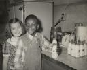
| Description: | A young boy and girl pose together as they take their bottles of milk at school. |
| Date: | 1947 |
|---|---|
| Description: | Food, Tobacco and Agriculture Workers session at Highlander. Connie Anderson, Educational Director for the organization, is standing in the center. |
| Date: | 1935 |
|---|---|
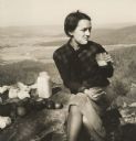
| Description: | A student at Highlander having a picnic behind the school. |
| Date: | |
|---|---|
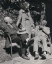
| Description: | Civil Rights workshop of Highlander participants partaking in an oyster feast on Johns Island. |

| Date: | |
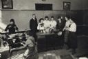
|---|---|
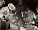
| Description: | A man holding a cigar is gesturing wildly. A portrait of Franklin Delano Roosevelt hangs behind him. An unidentified man and Catherine Winston sit on eit... |

| Date: | |
|---|---|
| Description: | J.C. McAmis (Mac) lecturing on organic food advocacy at Highlander. Poster in back reads, "Save Freedom of Speech". Myles Horton on left. |

| Date: | |
|---|---|
| Description: | Elevated view of the lunch room of Washington Irving High School, designed by the architect C.B.J. Snyder (1860-1945) and built in 1913. Lights hang from t... |
| Date: | 1920 |
|---|---|
| Description: | Group of agriculture students testing milk with teacher Gladys M. Smith at the Maplewood School. |
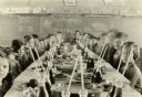
| Date: | 11 26 1930 |
|---|---|
| Description: | Students and teacher seated at a long table loaded with food and drinks for a Thanksgiving meal. There are music and English lessons behind them on the cha... |
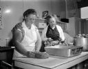
| Date: | 09 01 1954 |
|---|---|
| Description: | Cook Mrs. Clara Lehr and her assistant Mrs. Betty Hungate preparing lunch at Sunnyside School at 3902 East Washington Avenue. |

| Date: | 11 1980 |
|---|---|
| Description: | "Theresa Homemakers Club hosted other homemaker clubs at the Theresa Public School. Guest speaker, Ann Kaiser (right), editor of 'Country Women' magazine, ... |

| Date: | 1896 |
|---|---|
| Description: | A hand-colored Map of Jefferson County, Wisconsin, shows township and section divisions, towns, villages and post offices, rural residents, railroads, road... |

| Date: | 1909 |
|---|---|
| Description: | A map of Langlade County, Wisconsin that shows townships and ranges, towns, cities and villages, wagon roads, churches, schools, sawmills, town halls, chee... |

| Date: | 1915 |
|---|---|
| Description: | This 1915 map of Lincoln County, Wisconsin, shows the township and range grid, towns, cities and villages, lakes and streams, residences, churches, school ... |

| Date: | 1926 |
|---|---|
| Description: | A map of Lincoln County, Wisconsin that shows the township and range grid, towns, cities and villages, lakes and streams, residences, churches, school hous... |

| Date: | |
|---|---|
| Description: | This 1907 map of Outagamie County, Wisconsin, shows the township and range grid, towns, sections, cities and villages, railroads, wagon roads, churches, sc... |

| Date: | 1922 |
|---|---|
| Description: | This map of Outagamie County, Wisconsin, from the first half of the 20th century, shows the township and range grid, towns, sections, cities and villages, ... |
If you didn't find the material you searched for, our Library Reference Staff can help.
Call our reference desk at 608-264-6535 or email us at:
