 Filter: Categories of Wisconsin Historical Images
Filter: Subject of Schools
Filter: Subject of hunting
Filter: Categories of Wisconsin Historical Images
Filter: Subject of Schools
Filter: Subject of hunting

| Date: | 1867 |
|---|---|
| Description: | Bird's-eye map of Green Bay and Fort Howard, Brown Co., depicts street names and street layouts, houses, trees, and the East River. A reference key at the ... |
| Date: | |
|---|---|
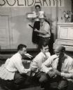
| Description: | A group of men imitating ducks, participating in a theatrical performance. A man wielding a shotgun is in the background, and is wearing a hat bearing the ... |
| Date: | 1937 |
|---|---|
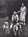
| Description: | Perry and Elsie Horton, parents of Myles Horton, with fox hounds, at Highlander Folk School. |

| Date: | 1908 |
|---|---|
| Description: | This map shows counties, roads, Lake Superior, Lake Michigan, and portions of surrounding states. Also included is a list of railroads showing miles and g... |

| Date: | 1910 |
|---|---|
| Description: | This map shows counties, roads, Lake Superior, Lake Michigan, and portions of surrounding states. Also included is a list of railroads showing miles and gr... |

| Date: | 1970 |
|---|---|
| Description: | This map shows roads, parks, swimming beaches, golf courses, yacht harbors, light houses, airports, public hunting grounds, waysides, schools, and fishing ... |
If you didn't find the material you searched for, our Library Reference Staff can help.
Call our reference desk at 608-264-6535 or email us at: