 Filter: Categories of Wisconsin Historical Images
Filter: Subject of Schools
Filter: Subject of lakes
Filter: Categories of Wisconsin Historical Images
Filter: Subject of Schools
Filter: Subject of lakes

| Date: | 1867 |
|---|---|
| Description: | Birds-eye drawing of Beaver Dam, Dodge Co., depicting street names and street layout, houses, rivers, lakes, and trees. A reference key at the bottom of th... |
| Date: | |
|---|---|
| Description: | Children swimming in a lake as part of Highlander Folk School's Koinonia Children's Camp. |
| Date: | |
|---|---|
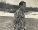
| Description: | Myles Horton, co-founder of the Highlander Folk School, walking near lake. On the patio of the Horton house. |
| Date: | |
|---|---|
| Description: | Mine, Mill & Smelters Union reading by a lake at Highlander Folk School. Will Thomas, second on the right, smoking a pipe. |

| Date: | |
|---|---|
| Description: | Farmers Union School gathering at Highlander. A.A. Liveright smoking a pipe and holding a camera, left; Paul Bennett, right. |

| Date: | |
|---|---|
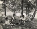
| Description: | Farmers Union workshop outdoors near water at Highlander Folk School. B.R. Brazeal is on the extreme left. May Justus, Highlander's Secretary-Treasurer, a... |

| Date: | |
|---|---|
| Description: | Civil rights group meeting in field at Highlander Lake. Fifth from the left, Charlotte Meacham, American Friends Service Committee, former Highlander stud... |

| Date: | |
|---|---|
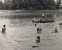
| Description: | Youth project and children's campers swimming in Highlander Lake |

| Date: | 1913 |
|---|---|
| Description: | A wall atlas of Sauk County, Wisconsin, displaying its 22 towns. On the left side are advertisements for local businesses. |

| Date: | 1900 |
|---|---|
| Description: | Perspective drawing of the buildings at the Hayward Indian School. There is a man in a boat in the right foreground and an empty boat in the left foregroun... |

| Date: | 03 14 1973 |
|---|---|
| Description: | Letter from Michael Bystry to Senator James Swan regarding school funding. The letter is written on S.W. Dairy Corp letterhead. The letterhead features an ... |

| Date: | 1939 |
|---|---|
| Description: | This map shows the towns to Gingles, Sanborn, and Guney as well as Chequamegon Bay, Kakagon River, White River, Marengo River, Bad River, Potato River, Vau... |

| Date: | 1880 |
|---|---|
| Description: | A hand-colored map of the Chippewa, Price, Taylor and the northern part of Clark counties, which shows the locations of farmhouses, schoolhouses, churches,... |

| Date: | 1881 |
|---|---|
| Description: | A brochure with a map of Wisconsin that also includes information (in English, German, Norwegian, and Swedish) pertaining to the state, such as its timber ... |

| Date: | 05 1846 |
|---|---|
| Description: | Hand-colored map of southeastern Wisconsin showing the counties of Dodge, Jefferson, Rock, Walworth, Racine (including modern-day Kenosha County), Waukesha... |
| Date: | 1908 |
|---|---|
| Description: | This map shows townships and sections, landownership, schools, and churches. Includes text explaining survey system. |

| Date: | 1896 |
|---|---|
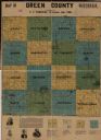
| Description: | A map of Green Lake County, Wisconsin, shows township divisions, villages and post offices, railroads, roads, lakes and streams, schools, and churches. |

| Date: | |
|---|---|
| Description: | A map that shows the Wisconsin Central Railway land grant lands for sale by the Soo Line, the Chicago, Milwaukee, and St. Paul Railway. Town sections, lak... |

| Date: | 1896 |
|---|---|
| Description: | A hand-colored Map of Jefferson County, Wisconsin, shows township and section divisions, towns, villages and post offices, rural residents, railroads, road... |
If you didn't find the material you searched for, our Library Reference Staff can help.
Call our reference desk at 608-264-6535 or email us at:
