 Filter: Categories of Wisconsin Historical Images
Filter: Subject of Schools
Filter: Subject of prairies
Filter: Categories of Wisconsin Historical Images
Filter: Subject of Schools
Filter: Subject of prairies

| Date: | 05 1846 |
|---|---|
| Description: | Hand-colored map of southeastern Wisconsin showing the counties of Dodge, Jefferson, Rock, Walworth, Racine (including modern-day Kenosha County), Waukesha... |
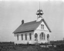
| Date: | 1921 |
|---|---|
| Description: | Exterior of the public schoolhouse, which features a bell tower and two arched entrances. |
If you didn't find the material you searched for, our Library Reference Staff can help.
Call our reference desk at 608-264-6535 or email us at: