 Filter: Categories of Wisconsin Historical Images
Filter: Subject of Schools
Filter: Subject of service industries
Filter: Categories of Wisconsin Historical Images
Filter: Subject of Schools
Filter: Subject of service industries

| Date: | 1867 |
|---|---|
| Description: | Bird's-eye map of Green Bay and Fort Howard, Brown Co., depicts street names and street layouts, houses, trees, and the East River. A reference key at the ... |

| Date: | 1880 |
|---|---|
| Description: | Bird's-eye map over the Mississippi River of Fountain City. Paddle steamers and steamboats are on the river, and bluffs are in the background. |
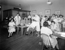
| Date: | 09 29 1932 |
|---|---|
| Description: | Interior of the Duncan Academy of Hair and Beauty Culture School, located at 23 South Pinckney Street. Students are working with customers in hair styling ... |

| Date: | 06 01 1931 |
|---|---|
| Description: | Portrait of George Topp and Steve Carvello, both from Blessed Sacrament School, with golf clubs, golf champions, on the Glenway golf course. |
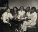
| Date: | |
|---|---|
| Description: | A group of Highlander Folk School students on an outing, eating dinner at a restaurant. |
| Date: | |
|---|---|
| Description: | Two instructors, Beatrice and Leon Lamoreux, teaching Naval students telegraphy at the U.S. Naval Training School (Radio). |
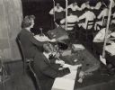
| Date: | |
|---|---|
| Description: | One Naval student operates a telegraph while another student observes, listening with earphones, at the U.S. Naval Training School (Radio). A typewriter is... |
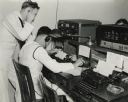
| Date: | |
|---|---|
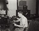
| Description: | A man testing telegraph equipment at the U.S. Naval Training School (Radio). |
| Date: | |
|---|---|
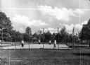
| Description: | Four uniformed female students play tennis on a fenced-in tennis court at St. Ann's school. The court is surrounded by trees, a pavilion, and buildings ar... |
| Date: | 07 1951 |
|---|---|
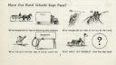
| Description: | Graphic from University of Wisconsin Extension Service Special Circular 20 showing progress in transportation and economics and posing the question "have o... |
| Date: | 1937 |
|---|---|
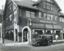
| Description: | View across street of an International D-2 panel truck owned by the Troy Towel Supply Company parked outside Warner Beauty College. A man is walking on the... |
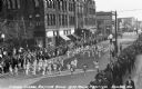
| Date: | 1939 |
|---|---|
| Description: | Elevated view of students from the Grade School Rhythm Band at the Music Festival, marching down Main Street. Students are wearing light or white clothing ... |

| Date: | |
|---|---|
| Description: | "Theresa firemen pose for a picture at the Theresa Public School." |

| Date: | 1896 |
|---|---|
| Description: | A map of Green Lake County, Wisconsin, shows township divisions, villages and post offices, railroads, roads, lakes and streams, schools, and churches. |

| Date: | 1870 |
|---|---|
| Description: | A map of Iowa County, Wisconsin mounted on cloth that shows the villages of Avoca, Mifflin, Linden, Arena, Helena Station, Highland, Dodgeville, as well as... |

| Date: | 1900 |
|---|---|
| Description: | A map of Jefferson County, Wisconsin, that identifies named hills, other points of interest, and the Lake Mills moraine system in the county and identifies... |

| Date: | 1915 |
|---|---|
| Description: | This 1915 map of Lincoln County, Wisconsin, shows the township and range grid, towns, cities and villages, lakes and streams, residences, churches, school ... |

| Date: | 1886 |
|---|---|
| Description: | A hand-colored map of Milwaukee County, Wisconsin that shows the township and range system, sections, towns, roads, railroads and rail stations, cities and... |

| Date: | 1891 |
|---|---|
| Description: | A hand-colored map of Milwaukee County, Wisconsin that shows the township and range system, sections, towns, roads, railroads and rail stations, cities and... |
If you didn't find the material you searched for, our Library Reference Staff can help.
Call our reference desk at 608-264-6535 or email us at:
