Filter: Categories of Wisconsin Historical Images
Filter: Subject of Schools
Filter: Subject of streets
Filter: Categories of Wisconsin Historical Images
Filter: Subject of Schools
Filter: Subject of streets

| Date: | 1890 |
|---|---|
| Description: | Bird's-eye map of Beloit with insets of Williams Engine Works, Eclipse Wind Engine Co., and John Foster & Co. Turtle Creek is in the lower section, and the... |

| Date: | 1867 |
|---|---|
| Description: | Bird's-eye map of Green Bay and Fort Howard, Brown Co., depicts street names and street layouts, houses, trees, and the East River. A reference key at the ... |

| Date: | 1880 |
|---|---|
| Description: | Bird's-eye map over the Mississippi River of Fountain City. Paddle steamers and steamboats are on the river, and bluffs are in the background. |

| Date: | 1881 |
|---|---|
| Description: | Bird's-eye map of Milton Junction. |

| Date: | 1879 |
|---|---|
| Description: | This map is a bird's-eye view of Wausau, the County Seat of Marathon County. The map features an index of points of interest. |

| Date: | |
|---|---|
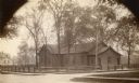
| Description: | Kehl's Dancing Academy, later used as the Labor Temple. A roofed entrance is over the sidewalk. |
| Date: | |
|---|---|
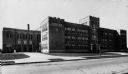
| Description: | View across street towards the South Side Junior High School in Sheboygan. |
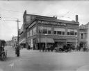
| Date: | 04 01 1915 |
|---|---|
| Description: | Northwest corner of 3rd and Wells Street, facing the Milwaukee Commercial School. A police officer directs traffic in the foreground, with pedestrians on t... |

| Date: | 1928 |
|---|---|
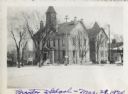
| Description: | View of the Randall School area, showing special street traffic signs on the road at the school crossing. In addition there are numerous children visible o... |
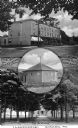
| Date: | 1890 |
|---|---|
| Description: | Composite image combining Girard, Pennsylvania landmarks. At the top is "The Old Keystone," in the center is "The Dan Rice Ring Barn," and at the bottom is... |

| Date: | |
|---|---|
| Description: | View of Main Street, featuring shops, cars, and carriages. Washington State College, founded in 1890, can be seen on a hilltop beyond the street. |

| Date: | 1914 |
|---|---|
| Description: | Plat book of Waukesha County. Pages 14 - 15. |
| Date: | |
|---|---|
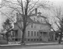
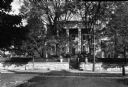
| Description: | View of Stuart Hall, a residential mansion used as the Virginia Female Institute. Chartered on January 13, 1744, the school is the state's oldest college p... |

| Date: | |
|---|---|
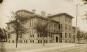
| Description: | Children stand on the sidewalk outside Public School Number Six, a tall brick building on a city block. |
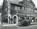
| Date: | 1937 |
|---|---|
| Description: | View across street of an International D-2 panel truck owned by the Troy Towel Supply Company parked outside Warner Beauty College. A man is walking on the... |
If you didn't find the material you searched for, our Library Reference Staff can help.
Call our reference desk at 608-264-6535 or email us at: