 Filter: Categories of Wisconsin Historical Images
Filter: Subject of Shipping
Filter: Subject of land use
Filter: Categories of Wisconsin Historical Images
Filter: Subject of Shipping
Filter: Subject of land use

| Date: | 1890 |
|---|---|
| Description: | Bird's-eye map of West Superior and Superior, with insets of Wright Farm and First Building in Superior. |
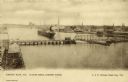
| Date: | 1900 |
|---|---|
| Description: | Looking North. Harbor with boats, bridge, and buildings. |
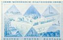
| Date: | 12 13 1947 |
|---|---|
| Description: | Design in blue for Wisconsin Centennial 3 cent postage stamp featuring a badger in a subtle "W" design. |

| Date: | 1910 |
|---|---|
| Description: | Elevated view of downtown. Part of the Milwaukee River is on the left side. Sign for the Germania building is in the lower right, and city hall is in the b... |

| Date: | 1902 |
|---|---|
| Description: | This map is a chart of Milwaukee Harbor that displays local streets, bridges, roads, railroads, public buildings, businesses, factories, dry docks, parks, ... |
If you didn't find the material you searched for, our Library Reference Staff can help.
Call our reference desk at 608-264-6535 or email us at: