 Filter: Categories of Wisconsin Historical Images
Filter: Subject of Shorelines
Filter: Community of Milwaukee
Filter: Subject of cities and towns
Filter: Categories of Wisconsin Historical Images
Filter: Subject of Shorelines
Filter: Community of Milwaukee
Filter: Subject of cities and towns

| Date: | 1910 |
|---|---|
| Description: | Popular bathing beaches like this one on Lake Michigan offered relief from the heat as well as the opportunity to be seen in the latest fashions of the 191... |

| Date: | 1856 |
|---|---|
| Description: | View looking west from Lake Michigan with several steam ships and sailing vessels in harbor. There is a lighthouse to left of center, along shoreline. |
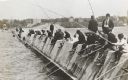
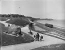
| Date: | 1910 |
|---|---|
| Description: | Long row of men in suits and hats fishing on the breakwater. |
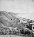
| Date: | 1877 |
|---|---|
| Description: | View of bluffs and buildings on the shore of Lake Michigan. |

| Date: | 1886 |
|---|---|
| Description: | Cover of an advertising brochure for the Milwaukee Harvester Company featuring a color chromolithograph illustration of a farmer in a field operating a hor... |

| Date: | 1872 |
|---|---|
| Description: | Bird's-eye map of Milwaukee on Lake Michigan. |

| Date: | 1898 |
|---|---|
| Description: | Bird's-eye map, looking west from shoreline on Lake Michigan of Milwaukee to Golden Lake in Waukesha County, with Kenosha and Fox Point at bottom corners, ... |

| Date: | 1886 |
|---|---|
| Description: | Bird's-eye view of Milwaukee from Bay View. |
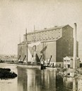
| Date: | 1870 |
|---|---|
| Description: | The Milwaukee & St. Paul Railway Company grain elevator at the Milwaukee harbor, with a sailing ship anchored nearby. |
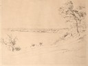
| Date: | 08 1852 |
|---|---|
| Description: | Pencil drawing of a lake shoreline. A few trees frame the arc of the shore and steamboats are visible along the distant shore. |

| Date: | 08 1852 |
|---|---|
| Description: | Pencil drawing of Milwaukee Harbor with large sailboats on the water. In the minimalist depiction the sandy shoreline with short plant growth sweeps aroun... |
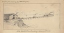
| Date: | 1850 |
|---|---|
| Description: | An illustration of the Old North Pier landing on Huron Street, drawn from memory. |

| Date: | 1906 |
|---|---|
| Description: | Polyconic projection. Map made from surveys without spirit level control. Henry Gannett, Chief Topographer. Topography by Van H. Manning and Nat. Tyler, Jr... |
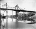
| Date: | 05 30 1914 |
|---|---|
| Description: | Juneau Park looking north from approximately E. Mason Street, with the Chicago and North Western railroad tracks on the right. The Lake Michigan shoreline ... |
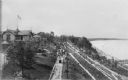
| Date: | 1914 |
|---|---|
| Description: | Elevated view of Pabst Whitefish Bay Resort on the shores of Lake Michigan, with crowds of individuals walking up the numerous paths that lead to the resor... |
| Date: | 06 08 1902 |
|---|---|
| Description: | Looking up the Milwaukee River to the Holton Street viaduct. In the center is the Gallun tannery. There is also a steamboat in the harbor, several lumber y... |

| Date: | |
|---|---|
| Description: | View of two steamboats, looking up the Milwaukee River from the north bank, near the foot of N. Milwaukee Street. Both steamboats are of the Goodrich Trans... |
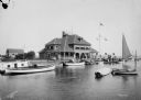
| Date: | 08 01 1914 |
|---|---|
| Description: | Milwaukee Yacht Club, located at the foot of E. Layfayette Street on Lake Michigan. Numerous sailboats are in the harbor, and individuals are on the pier. |
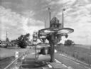
| Date: | 08 24 1971 |
|---|---|
| Description: | Tramway that was used by O.D. Hopkins Association Incorporated of Contoocook, New Hampshire. Falk caption reads, "Tramway (Skylark- customers, Sky Glider) ... |

| Date: | 1951 |
|---|---|
| Description: | Aerial view of Jones Island and garbage disposal plant. |
If you didn't find the material you searched for, our Library Reference Staff can help.
Call our reference desk at 608-264-6535 or email us at: