 Filter: Categories of Wisconsin Historical Images
Filter: Subject of Springs
Filter: Creator Name of Unknown
Filter: Categories of Wisconsin Historical Images
Filter: Subject of Springs
Filter: Creator Name of Unknown

| Date: | |
|---|---|
| Description: | View of the Sulpho-Saline Spring Pavilion, built in 1917 according to the plans of George Kessler and architect Henry F. Hoit. A woman sits on a bench outs... |

| Date: | |
|---|---|
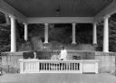
| Description: | Exterior of an office at the Excelsior Saline Water Company. Two United States flags mark the doorway, and benches line the exterior walls. On the front ... |
| Date: | |
|---|---|
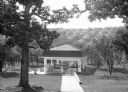
| Description: | A view of a bandstand and Pertle Springs, an iron-rich spring whose name comes from William S. Purtle, the owner of the land in the early 1800's. A man sit... |
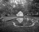
| Date: | |
|---|---|
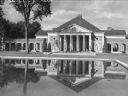
| Description: | Front view of the large, monumental Administration Building with a reflecting pool. Also known as the Simon Burach Building after the famed hydrotherapist,... |
| Date: | |
|---|---|
| Description: | A view of the magnesium spring at Bedford Springs Hotel, founded in 1806. A man pours water said to cure stomach ailments from the magnesium spring into a ... |
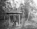
| Date: | |
|---|---|
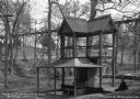
| Description: | View looking down into a covered shelter, built in the early 1900's, for Massanetta Springs. A group of people are sitting in the shelter which is in a cou... |
| Date: | 1910 |
|---|---|
| Description: | Wallace Bruce and a young girl rest at Alpine Park, near DeFuniak Springs. He is sitting on a well, and the girl is standing beside him under a covered she... |
| Date: | |
|---|---|
| Description: | View of a sanitarium bath near a pond at a sulphur spring. The waters were advertised to aid kidney and stomach troubles. |

| Date: | |
|---|---|
| Description: | A group of people bathe at Miller's Swimming Hole at Elk Springs. Three people prepare to dive into the water while others swim or sit on the rocks. |

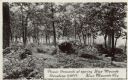
| Date: | |
|---|---|
| Description: | View of a spring on the way to River Pine Sanitarium, which opened in 1906. |

| Date: | |
|---|---|
| Description: | Two men stand near a geological formation in Mitchell's Glen, formerly owned by S. D. Mitchell. |
| Date: | |
|---|---|
| Description: | Photographic postcard of picnic grounds at a spring in Blue Mounds State Park. The spring is running out of a brick catch basin on the right. A woman weari... |
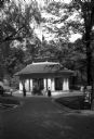
| Date: | |
|---|---|
| Description: | View down wide walkway toward a group gathered outside the entrance to the Pluto Spring Pavillion in a a wooded area. In the foreground at right is an adve... |

| Date: | 1941 |
|---|---|
| Description: | Hand-drawn, watercolor and ink, map of Lake Mendota. Locations and many small figures appear around the shore with explanations referring to Indian legends... |
| Date: | 1910 |
|---|---|
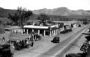
| Description: | Elevated view of a street scene. The Jacumba Hot Springs are advertised on top of a building housing a drug store, bakery and confectionary, and D & B Res... |
| Date: | |
|---|---|
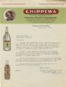
| Description: | Letterhead of the Chippewa Springs Corporation of Chippewa Falls, Wisconsin, featuring the Chippewa Natural Spring Water logo of an American Indian man in ... |

| Date: | 1835 |
|---|---|
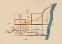
| Description: | Plat for a proposed Sinsinawa City (never built), in Grant County, Wis. When it became clear in the mid-1830s that Wisconsin Territory would be established... |
| Date: | 1918 |
|---|---|
| Description: | This map shows the property owned by Edwin Bottomley and others at the confluence of Eagle Creek with the Fox River in the Town of Rochester, Racine County... |
| Date: | |
|---|---|
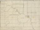
| Description: | This 19th century manuscript map shows First Lake, Second Lake, streams, and sections in the towns of Dunn and Pleasant Springs, Dane County, Wisconsin. |

| Date: | 1923 |
|---|---|
| Description: | This topographical map of Devil's Lake State Park, Sauk County, Wisconsin, is based on 1922-1923 surveys of the area by the University of Wisconsin Summer ... |
If you didn't find the material you searched for, our Library Reference Staff can help.
Call our reference desk at 608-264-6535 or email us at: