 Filter: Categories of Wisconsin Historical Images
Filter: Subject of Springs
Filter: Year of 1800-1899
Filter: Categories of Wisconsin Historical Images
Filter: Subject of Springs
Filter: Year of 1800-1899
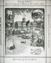
| Date: | 1883 |
|---|---|
| Description: | Tonyawatha Spring Hotel from a descriptive brochure. The hotel opened in 1879 and was destroyed by fire on July 31, 1895. |
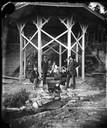
| Date: | 1875 |
|---|---|
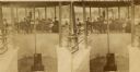
| Description: | "Mineral spring pavilion with visitors taking the waters." Seven adults, including a man in a top hat, five children and a woman are posing in a gazebo bui... |
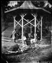
| Date: | 1875 |
|---|---|
| Description: | "Mineral spring pavilion with visitors taking the waters." Well-dressed men, women and children are posed in a gazebo built over the Iodo-Magnesian Springs... |
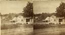
| Date: | 1877 |
|---|---|
| Description: | Stereograph view of Glenn's mineral spring. |
| Date: | 1877 |
|---|---|
| Description: | Stereograph view of Glenn's mineral spring with a group of people gathered around it. |

| Date: | 1889 |
|---|---|
| Description: | Cross in a field marking the area of "Marquette's well." |

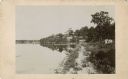
| Date: | 1896 |
|---|---|
| Description: | View of Silver Spring and the surrounding countryside. In the background, there is a man on a bicycle, two individuals in a horse-drawn vehicle and a small... |

| Date: | 06 06 1894 |
|---|---|
| Description: | A view at the mouth of the Wabash River of a lone tree on what appears to be a peninsula. |
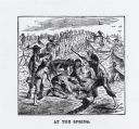
| Date: | 1863 |
|---|---|
| Description: | "At the Spring," a woodcut illustration from McElroy's "Andersonville: Story of Southern Prisons." |

| Date: | 1835 |
|---|---|
| Description: | Plat for a proposed Sinsinawa City (never built), in Grant County, Wis. When it became clear in the mid-1830s that Wisconsin Territory would be established... |
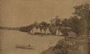
| Date: | 1885 |
|---|---|
| Description: | View along shoreline towards Tonyawatha House and several outbuildings on Lake Monona. There is a long dock extending into the lake from a boathouse on the... |

| Date: | 1864 |
|---|---|
| Description: | This map shows locations of quarries, sink holes, creeks, springs, rivers, houses, forts, and roads. Annotations in pencil read: "Is the top of the mound l... |

| Date: | 1864 |
|---|---|
| Description: | This map shows locations of quarries, sink holes, creeks, springs, rivers, houses, forts, and roads. The upper right corner and right margin includes anno... |

| Date: | 1864 |
|---|---|
| Description: | Map showing locations of quarries, sink holes, creeks, springs, rivers, houses, forts, and roads. The map appears to have been drawn on to of a plat map of... |

| Date: | 1864 |
|---|---|
| Description: | This map shows locations of quarries, sink holes, creeks, springs, rivers, houses, forts, and roads. |
| Date: | 08 30 1884 |
|---|---|
| Description: | View along the Lake Monona shoreline towards the Tonyawatha Spring Hotel. A crowd of people are standing on the pier with several sailboats. On the shore i... |
If you didn't find the material you searched for, our Library Reference Staff can help.
Call our reference desk at 608-264-6535 or email us at: