 Filter: Categories of Wisconsin Historical Images
Filter: Subject of Stadiums
Filter: Subject of transportation
Filter: Subject of cities and towns
Filter: Categories of Wisconsin Historical Images
Filter: Subject of Stadiums
Filter: Subject of transportation
Filter: Subject of cities and towns

| Date: | 1908 |
|---|---|
| Description: | Aerial view of Camp Randall Field on the University of Wisconsin-Madison campus. University Heights is in the background. |

| Date: | 1910 |
|---|---|
| Description: | A Wright airplane flying over a grandstand in Indianapolis, with a second unidentified plane in the foreground. This exhibition at the recently-constructed... |

| Date: | 1949 |
|---|---|
| Description: | Color bird's-eye map of the University of Wisconsin-Madison as it was midcentury, with two co-eds, several photographs of campus landmarks around edges, an... |
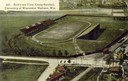
| Date: | 1934 |
|---|---|
| Description: | Aerial view of Camp Randall Stadium and Field House on the University of Wisconsin-Madison campus. |
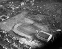
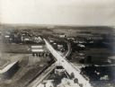
| Date: | 1908 |
|---|---|
| Description: | Aerial view of Camp Randall Stadium on the University of Wisconsin-Madison campus. Top image on Place File card. Caption reads: "Bird's-eye View, Camp Ra... |
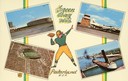
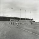
| Date: | 1957 |
|---|---|
| Description: | Composite image of "Packerland U.S.A." including prominent attractions: Lambeau Field, home of the Green Bay Packers, NFL Football team; the Brown County A... |
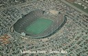
| Date: | 1965 |
|---|---|
| Description: | Aerial view of Lambeau Field, home the Green Bay Packers football team, with a full parking lot. The capacity of the stadium at the time of this photograp... |

| Date: | |
|---|---|
| Description: | Aerial view of a full Camp Randall Stadium during half-time of a football game. The band is on the field in formation to spell "UW." |
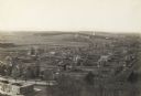
| Date: | 1907 |
|---|---|
| Description: | Elevated wiew looking west, probably from the chimney of the University of Wisconsin Power Plant. Camp Randall Stadium is in the lower left corner. |
| Date: | 1898 |
|---|---|
| Description: | Elevated view of Camp Randall and the neighborhoods west of Bascom Hall including University Heights. |
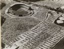
| Date: | 1952 |
|---|---|
| Description: | Home baseball park for the Milwaukee Braves baseball team. The field is on the upper left, with the rest of the image taken over by the full parking lots. |
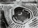
| Date: | |
|---|---|
| Description: | Home field of the Milwaukee Braves baseball team. The field is in the center, and is surrounded by a parking lot full of automobiles. |

| Date: | 1945 |
|---|---|
| Description: | Aerial view of married student housing located next to the baseball field near Camp Randall stadium and the Field House. |

| Date: | 1959 |
|---|---|
| Description: | University of Wisconsin-Madison campus. Numbers in circles identify buildings across campus with the building index. Black arrows point out important infor... |
| Date: | 1973 |
|---|---|
| Description: | Green Bay Packers quarterbacks, Jerry Tagge (#17) and Scott Hunter (#16), ride bicycles loaned to them by young fans from Lambeau Field to their practice f... |
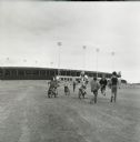
| Date: | 1973 |
|---|---|
| Description: | Green Bay Packers Center, Larry McCarren (#54) walking across the Lambeau Field parking lot toward the practice field. Several young fans seeking autograph... |
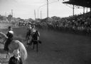
| Date: | 07 04 1947 |
|---|---|
| Description: | Ring at the Cedarburg horse show with cowgirls and cowboys. On the right are crowd-filled bleachers behind fence. |
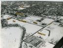
| Date: | 1965 |
|---|---|
| Description: | Aerial view of the UW-Madison campus near University Bay in winter. Labels are pasted to the print to indicate Elm Dr., the gym, Camp Randall Stadium, the ... |

| Date: | 1968 |
|---|---|
| Description: | A tourist map of Milwaukee County and of downtown Milwaukee. The Map of Milwaukee County identifies the location of some of the points of interests in the ... |

| Date: | 1950 |
|---|---|
| Description: | Includes building index and "To Help You Locate Buildings" text. Index includes campus buildings and points of interest. Aerial view on verso. |
If you didn't find the material you searched for, our Library Reference Staff can help.
Call our reference desk at 608-264-6535 or email us at: