 Filter: Categories of Wisconsin Historical Images
Filter: Subject of Streams
Filter: County of Eau Claire
Filter: Categories of Wisconsin Historical Images
Filter: Subject of Streams
Filter: County of Eau Claire

| Date: | 1960 |
|---|---|
| Description: | This map shows lot numbers and dimensions, railroad, and streets. Fall Creek and Mill Pond (now Fall Creek Pond) are labeled. The map is a blue line print. |
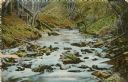
| Date: | 1908 |
|---|---|
| Description: | View of Sherman creek. Caption reads: "Sherman Creek, Eau Claire, Wis." |
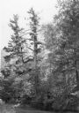
| Date: | 1980 |
|---|---|
| Description: | A tall white pine standing along Lowe's Creek south of Eau Claire. The top of the main trunk has been broken off and a secondary leader has grown from a ho... |
If you didn't find the material you searched for, our Library Reference Staff can help.
Call our reference desk at 608-264-6535 or email us at: