 Filter: Categories of Wisconsin Historical Images
Filter: Subject of Streams
Filter: County of Sheboygan
Filter: Categories of Wisconsin Historical Images
Filter: Subject of Streams
Filter: County of Sheboygan

| Date: | 1862 |
|---|---|
| Description: | This 1862 map of Sheboygan County, Wisconsin, shows land ownership and acreages, the township and range grid, towns, cities and villages, roads, railroads,... |

| Date: | 1934 |
|---|---|
| Description: | This 1930s highway map of Sheboygan County, Wisconsin, shows roads, the township and range grid, towns, sections, cities and villages, and streams, lakes, ... |

| Date: | 1906 |
|---|---|
| Description: | This map of Sheboygan County, Wisconsin, from the early 20th century shows school districts and school locations in the county. Also shown are the township... |

| Date: | 1972 |
|---|---|
| Description: | This map of Sheboygan County, Wisconsin, shows the location of churches in the county. Churches are indexed for each town. Also shown are sections, cities ... |
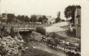
| Date: | 1908 |
|---|---|
| Description: | View of a street going through the center of town. In the foreground is a stream and a bridge. Commercial buildings and dwellings are on the left. |
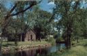
| Date: | |
|---|---|
| Description: | Ektachrome postcard of the blacksmith shop next to a stream. Text on reverse reads: "The Blacksmith Shop was Sylvanus Wade's first venture in Greenbush.... |
If you didn't find the material you searched for, our Library Reference Staff can help.
Call our reference desk at 608-264-6535 or email us at: