 Filter: Categories of Wisconsin Historical Images
Filter: Subject of Streams
Filter: County of Walworth
Filter: Type of Map or Atlas
Filter: Categories of Wisconsin Historical Images
Filter: Subject of Streams
Filter: County of Walworth
Filter: Type of Map or Atlas
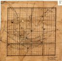
| Date: | 1840 |
|---|---|
| Description: | This 19th century manuscript map shows the roads and proposed routes, villages, and lakes and streams in Walworth County, Wisconsin. |

| Date: | 1896 |
|---|---|
| Description: | This late 19th century map of Walworth County, Wisconsin, shows the township and range grid, towns, sections, villages and post offices, roads, railroads, ... |

| Date: | 1900 |
|---|---|
| Description: | This 1900 map of Walworth County, Wisconsin, shows the township and range grid, towns, sections, landownership and acreages, rural residences, cities and v... |

| Date: | 01 01 1935 |
|---|---|
| Description: | This 1935 map of Walworth County, Wisconsin, shows the township and range grid, towns, sections, cities and villages, highways and roads, railroads, school... |

| Date: | 1939 |
|---|---|
| Description: | This map of Walworth County, Wisconsin, shows the township and range grid, sections, cities and town, and lakes and streams in the county. It lacks the key... |

| Date: | 1939 |
|---|---|
| Description: | This map of Walworth County, Wisconsin, shows the lakes and streams flowing into the Fox River and the lakes and streams flowing into the Rock River. The d... |
If you didn't find the material you searched for, our Library Reference Staff can help.
Call our reference desk at 608-264-6535 or email us at: