 Filter: Categories of Wisconsin Historical Images
Filter: Subject of Streams
Filter: Subject of housing
Filter: Categories of Wisconsin Historical Images
Filter: Subject of Streams
Filter: Subject of housing
| Date: | |
|---|---|
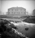
| Description: | The Root River swollen with rainwater and/or snow melt. A recently built duplex housing unit is visible in the background. This picture was likely taken as... |
| Date: | |
|---|---|
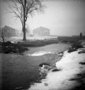
| Description: | The Root River, swollen with rainwater and/or snow melt, runs under a bridge on which a man is walking. Recently built houses are visible in the misty back... |

| Date: | |
|---|---|
| Description: | View of Perrine's Ranch, located in the vicinity of Twin Falls. A man is crossing a stream filled with large rock boulders. The ranch is on the left side o... |

| Date: | 1926 |
|---|---|
| Description: | A topographic map of Green County, showing by contours and spot heights the topographic and natural features of the county. The contour intervals are 20 fe... |

| Date: | 1911 |
|---|---|
| Description: | This 1911 map from the U.S. Post Office Dept. shows rural delivery routes, active and discontinued post offices, collection boxes, selected rural landowner... |

| Date: | 1911 |
|---|---|
| Description: | This 1911 map from the U.S. Post Office Department shows rural delivery routes, active and discontinued post offices, selected rural landowners and houses,... |
If you didn't find the material you searched for, our Library Reference Staff can help.
Call our reference desk at 608-264-6535 or email us at: