 Filter: Categories of Wisconsin Historical Images
Filter: Subject of Streams
Filter: Subject of industries
Filter: Categories of Wisconsin Historical Images
Filter: Subject of Streams
Filter: Subject of industries
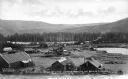
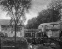
| Date: | 1920 |
|---|---|
| Description: | View from hill towards the Small mill, with adjacent stream. |
| Date: | 1939 |
|---|---|
| Description: | A man operates an International TD-18 TracTracTor (crawler tractor) to deepen a creek channel. Original caption reads: "TD-18 TracTracTor and Emseo(?) Bull... |

| Date: | |
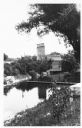
|---|---|
| Description: | Elevated view down hill toward old mill with a small bridge in the foreground, and another arched bridge over a steep-sided stream in City Park. Paths and ... |
| Date: | |
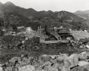
|---|---|
| Description: | Elevated view of dredging operations at the mouth of Bear Creek in Canada. Caption reads: "Dredging Operations at the Mouth of Bear Creek, Dawson, Y.T." |
| Date: | |
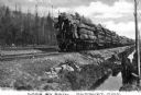
|---|---|
| Description: | Three men are standing on the last railroad car which is carrying logs down a railroad track. Another set of tracks are running parallel on the left, and b... |
| Date: | |
|---|---|
| Description: | A view of a grist mill and sawmill with a waterfall between them. Caption reads: "Grist and Saw Mill." |
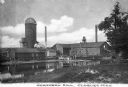
| Date: | |
|---|---|
| Description: | View from shoreline across water toward the mill. To the right of the main building are two smaller structures, with a watertower and silo behind. Two smok... |

| Date: | |
|---|---|
| Description: | Letterhead of Madison Mobile Homes, with a three-quarter view of a mobile home parked in a clearing near a wooded area on a shoreline, with the slogan "Liv... |

| Date: | |
|---|---|
| Description: | Map of northern Iron County, Wisconsin, shows town sections and railroads in the towns of Saxon, Kimball, and Gurney. It also includes the area of the La P... |

| Date: | 1866 |
|---|---|
| Description: | A map of Lafayette County, Wisconsin, showing the townships and ranges, sections, towns, villages, stream and rivers, mounds, mineral deposits and the Mine... |

| Date: | 1915 |
|---|---|
| Description: | This 1915 map of Lincoln County, Wisconsin, shows the township and range grid, towns, cities and villages, lakes and streams, residences, churches, school ... |

| Date: | 1914 |
|---|---|
| Description: | This 1914 map of Price County, Wisconsin, shows land for sale by the Good Land Company and Dewitt van Ostrand of Phillips. Also shown are the township and ... |

| Date: | 1890 |
|---|---|
| Description: | This late 19th century map shows mining companies' lands and miscellaneous properties in the towns of Cady and Springfield in southeastern Saint Croix Coun... |

| Date: | 1896 |
|---|---|
| Description: | This 1898 map shows the township and range system, sections, cities and villages, railroads, roads, vacant land and land sold by the Wisconsin Central Rail... |

| Date: | 1900 |
|---|---|
| Description: | This 1900 map shows the township and range system, sections, cities and villages, railroads, roads, vacant land and land sold by the Wisconsin Central Rail... |

| Date: | 1886 |
|---|---|
| Description: | This map of Ashland County, Wisconsin, which at the time included part of present-day Iron County, also covers portions of Vilas County, Wisconsin, then pa... |

| Date: | 1887 |
|---|---|
| Description: | This map shows mining properties in the Gogebic Range between Atkins Lake, in Sawyer County, Wisconsin, on the west and Lake Gogebic, Michigan, on the east... |

| Date: | 1917 |
|---|---|
| Description: | This map, which highlights the land for sale by the Rust-Owen Lumber Company in the towns of Drummond, Cable and Grandview, Bayfield County, Wisconsin, sho... |

| Date: | 1887 |
|---|---|
| Description: | This 1896 map shows the township and range system, sections, cities and villages, railroads, roads, vacant land and land sold by the Wisconsin Central Rail... |

| Date: | 1898 |
|---|---|
| Description: | This 1898 map shows the township and range system, sections, cities and villages, railroads, roads, vacant land and land sold by the Wisconsin Central Rail... |
If you didn't find the material you searched for, our Library Reference Staff can help.
Call our reference desk at 608-264-6535 or email us at: