 Filter: Categories of Wisconsin Historical Images
Filter: Subject of Streams
Filter: Subject of persons
Filter: Categories of Wisconsin Historical Images
Filter: Subject of Streams
Filter: Subject of persons
| Date: | 1912 |
|---|---|
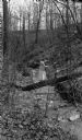
| Description: | A woman and small girl balance on a log crossing a small stream in a ravine. The trees and bushes are bare. |
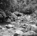
| Date: | 04 1922 |
|---|---|
| Description: | The photographer's wife Clothilde leans on a railing, looking at water rushing through a stone culvert on Fish Creek. Their car is parked on the roadway. A... |
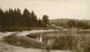
| Date: | 1920 |
|---|---|
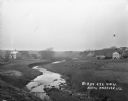
| Description: | View from low hill of a stream flowing through fields. There are cows in the pasture on the right. In the distance is a bridge, road, and buildings. |
| Date: | 1915 |
|---|---|
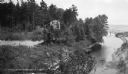
| Description: | Elevated view of a two-story house sited beside Shivering Sands Creek where it enters Lake Michigan. There is a rustic footbridge over the stream close to ... |
| Date: | 1920 |
|---|---|
| Description: | View along shoreline towards a rustic foot bridge which crosses the mouth of Fish Creek, which separates the village of Fish Creek from Peninsula State Par... |

| Date: | |
|---|---|
| Description: | Two cows are walking down to a stream in the woods. A field is in the background on the left. |

| Date: | 1946 |
|---|---|
| Description: | A map showing the roads, railroads, towns, cities and villages, streams and lakes, airports, schools, churches, cemeteries, and golf courses in Kenosha Cou... |

| Date: | 1897 |
|---|---|
| Description: | Topographical map of Stanley McCormick's Riven Rock estate in El Montecito, Santa Barbara County, California. The map is identified as a map of a survey co... |
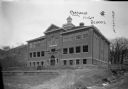
| Date: | 1913 |
|---|---|
| Description: | View of facade of high school. The grounds in front are still bare dirt. In the background is a steep hill. A small bridge is over a narrow stream on the r... |

| Date: | 1965 |
|---|---|
| Description: | Color illustration of an International Scout 800, a standard Scout engine and an optional turbocharged engine. The Scout 800 truck is shown being driven th... |

| Date: | |
|---|---|
| Description: | This 1907 map of Outagamie County, Wisconsin, shows the township and range grid, towns, sections, cities and villages, railroads, wagon roads, churches, sc... |
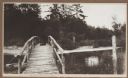
| Date: | 1915 |
|---|---|
| Description: | A rustic foot bridge over Fish Creek connects Peninsula State Park (foreground) with the village of Fish Creek. The Vits house is at the right end of the b... |
| Date: | 1915 |
|---|---|
| Description: | View from the Vits property, looking east, across a rustic foot bridge over Fish Creek leading to Peninsula State Park. A dachshund rests in the middle of ... |

| Date: | 1960 |
|---|---|
| Description: | This mid-20th century tourist brochure for Bayfield County, Wisconsin, includes a map of the county showing towns, cities and villages, highways and roads,... |
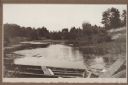
| Date: | 1915 |
|---|---|
| Description: | A wooden boat forms the foreground of a view of a stream, probably Shivering Sands Creek, and wetlands, with a sand dune on the right. |

| Date: | 1860 |
|---|---|
| Description: | This map of Dodge County, Wisconsin, shows the township and range grid, towns, sections, cities and villages, railroads, roads, property owners and acreage... |
| Date: | 10 24 1943 |
|---|---|
| Description: | Robert Doyle's caption says it best, "The ol' swimmin' hole, South Pacific style. Every afternoon it is filled with shouting soldiers in their birthday sui... |
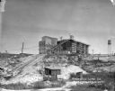
| Date: | 1924 |
|---|---|
| Description: | View from low section of quarry towards the processing plant up a steep rise. Tracks for hauling limestone are on the left near small sheds and a marshy ar... |
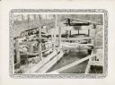
| Date: | 1932 |
|---|---|
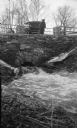
| Description: | An open wooden structure built over a small mill race supports a vertical water wheel. A large belt runs horizontally from the water wheel to a line shaft ... |

| Date: | 1970 |
|---|---|
| Description: | Photographer Fritz Albert wading through a stream in order to take a picture of congressional candidate David R. Obey meeting with a group of students near... |
If you didn't find the material you searched for, our Library Reference Staff can help.
Call our reference desk at 608-264-6535 or email us at: