Filter: Categories of Wisconsin Historical Images
Filter: Subject of Streams
Filter: Subject of water
Filter: Categories of Wisconsin Historical Images
Filter: Subject of Streams
Filter: Subject of water
| Date: | |
|---|---|
| Description: | A farm boy is riding the "hay-fork horse" as the farmer is loading hay into the barn during haying time in July. |
| Date: | |
|---|---|
| Description: | A threshing scene during harvest time. In the background, the separater tender stands on the thresher overseeing the whole operation. He has a weighing dev... |
| Date: | 1980 |
|---|---|
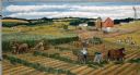
| Description: | Farmers work cooperatively with their horse teams on silo-filling activities early in autumn. Rows of green forage are created in the fields and carried to... |
| Date: | |
|---|---|
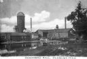
| Description: | View from shoreline across water toward the mill. To the right of the main building are two smaller structures, with a watertower and silo behind. Two smok... |

| Date: | 1942 |
|---|---|
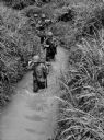
| Description: | Rear view of soldiers holding their rifles above their heads as they ford a stream in Panama. |

| Date: | |
|---|---|
| Description: | View from above of a soldier fording a stream with grassy banks near Fort Davis, Panama, holding his rifle over his head. He is wearing fatigues and a bac... |
| Date: | |
|---|---|
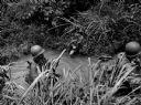
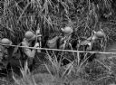
| Description: | Soldiers ford a stream in Panama holding their rifles. |
| Date: | |
|---|---|
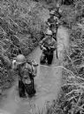
| Description: | Elevated view of soldiers fording a stream in Panama. |
| Date: | |
|---|---|
| Description: | Soldiers fording a stream in Panama holding rifles high. |

| Date: | |
|---|---|
| Description: | Exterior photograph of the first water works in America, consisting of a stone cottage next to a stream. |

| Date: | 1930 |
|---|---|
| Description: | Pictorial map of Glacier National Park, Montana and Waterton Lakes National Park, Alberta. Illustrated by Joe Scheurle, it depicts white people, American ... |

| Date: | 1930 |
|---|---|
| Description: | The back of the pictorial map titled Recreational Map of Glacier National Park, Montana: Waterton Lakes National Park, Alberta. 14 panels of text and photo... |

| Date: | 1864 |
|---|---|
| Description: | View down to valley of Union soldiers posing on the roof of a log building. A log bridge crosses a stream, and many trees are on the hillsides. Plate 05... |

| Date: | 10 1884 |
|---|---|
| Description: | Sanborn insurance map of Black River Falls covering the area bordered by the Black River on the East, 3rd Street on the West, Johnson Street on the North, ... |

| Date: | |
|---|---|
| Description: | Elevated view of a tree-lined stream, its banks, and a bridge in the distance. |

| Date: | |
|---|---|
| Description: | View upriver toward the bridge. A wooden structure is to the left of the bridge. Caption reads: "North Street Bridge, Whitewater, Wis." |

| Date: | 1943 |
|---|---|
| Description: | Holiday card with two flamingos standing in a stream with water lilies. Palm trees are on the banks. The right edge is die cut. |
If you didn't find the material you searched for, our Library Reference Staff can help.
Call our reference desk at 608-264-6535 or email us at: