 Filter: Categories of Wisconsin Historical Images
Filter: Subject of Streetcars
Filter: Subject of human settlements
Filter: Community of Milwaukee
Filter: Categories of Wisconsin Historical Images
Filter: Subject of Streetcars
Filter: Subject of human settlements
Filter: Community of Milwaukee
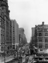
| Date: | 1930 |
|---|---|
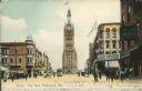
| Description: | View down Wisconsin Avenue looking east. |
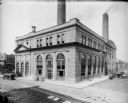
| Date: | |
|---|---|
| Description: | The Oneida Street (East Wells) power plant, on the north side of Wells and east of the Milwaukee River. Presently, the building is the Milwaukee Repertory ... |

| Date: | 1870 |
|---|---|
| Description: | Slightly elevated view at an angle towards the left and front of the courthouse. A large statue is on top of the main dome. The area around the courthouse ... |

| Date: | 1911 |
|---|---|
| Description: | Three women in large hats walking away from two streetcars on a windy day. Other men and women are standing in the background. One of the streetcars has a ... |
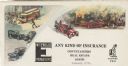
| Date: | |
|---|---|
| Description: | Letterhead of the Wm. Ewig Company, an insurance company in Milwaukee, Wisconsin, with full-color depictions of a scene with three traffic accidents involv... |

| Date: | 1869 |
|---|---|
| Description: | This map was engraved from original drawings and surveys taken by Louis Lipman. Includes Milwaukee street directory on the left hand side. Bottom right cor... |
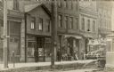
| Date: | |
|---|---|
| Description: | Street view in the S. Sixth Street neighborhood of Walker's Point. The storefronts include the H.J. Heinz Co.; H. Mullen, a clothing and shoe store; J. Ger... |
| Date: | |
|---|---|
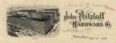
| Description: | Letterhead of the John Pritzlaff Hardware Company, with an elevated three-quarter view of the company building. |

| Date: | 1901 |
|---|---|
| Description: | This map shows public schools, engine houses, railroads, street railways, city wards, parks, block numbers, and Lake Michigan. Also included are indexes, t... |

| Date: | 1904 |
|---|---|
| Description: | This map has three inset maps of Whitefish Bay, Cudahy, and South Milwaukee. This map depicts schools, engine houses, railroads, street railways, city ward... |

| Date: | 1904 |
|---|---|
| Description: | This map shows wards, schools, engine houses, railroads, street railways, block numbers, parks, roads, and Lake Michigan. Also included are indexes: Table ... |

| Date: | 1907 |
|---|---|
| Description: | This map shows ward numbers, streets, railroads, electric car lines, parks, steam railways, section numbers, Lake Michigan and one mile concentric circles ... |

| Date: | 1911 |
|---|---|
| Description: | This map shows ward numbers, streets, railroads, electric car lines, parks, steam railways, section numbers, Lake Michigan and one mile concentric circles ... |

| Date: | 1912 |
|---|---|
| Description: | This map shows ward numbers, streets, railroads, electric car lines, parks, steam railways, section numbers, Lake Michigan and one mile concentric circles ... |

| Date: | 1916 |
|---|---|
| Description: | This map shows ward numbers, streets, railroads, electric car lines, parks, steam railways, section numbers, rivers, Lake Michigan, churches, schools, and ... |

| Date: | 1910 |
|---|---|
| Description: | This ink on paper blue line print base map consists of eight separate pieces and shows city limits, The Milwaukee Electric Railroad & Light Company lines, ... |

| Date: | 1927 |
|---|---|
| Description: | This map shows highways, roads, a proposed annexation, street car lines, bus routes, local motor bus lines, a new high speed interurban, railroads, a propo... |

| Date: | |
|---|---|
| Description: | View through a City Hall archway of the city square, which includes a statue, a streetcar, and a decorative lamp post. Caption reads: "City Hall Square, Mi... |

| Date: | |
|---|---|
| Description: | Elevated view from City Hall Square, including the Blatz Hotel, Pabst Theater, a fountain, and a streetcar. Caption reads: "City Hall Square, Blatz Hotel a... |
| Date: | |
|---|---|
| Description: | A view of City Hall from the square, including the Miller Cafe, other businesses, pedestrians, and a streetcar. Caption reads: "City Hall, Milwaukee, Wis."... |
If you didn't find the material you searched for, our Library Reference Staff can help.
Call our reference desk at 608-264-6535 or email us at: