 Filter: Categories of Wisconsin Historical Images
Filter: Subject of Streets
Filter: County of Grant
Filter: Categories of Wisconsin Historical Images
Filter: Subject of Streets
Filter: County of Grant
| Date: | |
|---|---|
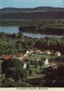
| Description: | Elevated view of Stonefield Village, with the Mississippi River in the background. Caption reads: "Stonefield, Cassville, Wis." |
| Date: | |
|---|---|
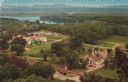
| Description: | Color postcard of an elevated view of Stonefield Village with the Mississippi River in the background and railroad tracks in the foreground. |
| Date: | |
|---|---|
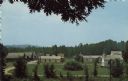
| Description: | Elevated color postcard view of Stonefield Village from across the churchyard. |
| Date: | 1973 |
|---|---|
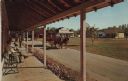
| Description: | Color postcard of Main Street from porch on building at Stonefield Village. A horse bus with tourists is in the street. |

| Date: | 1971 |
|---|---|
| Description: | Slightly elevated view of a central business district. The theater marquee on the left reads: "The Concert for Bangladesh." Across the street on the right ... |

| Date: | 1850 |
|---|---|
| Description: | This map of Cassville shows plat of town, roads, and the Mississippi River. Relief is shown by hachures. The map includes an inset map of a Plat of townshi... |
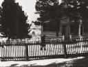
| Date: | 1895 |
|---|---|
| Description: | Pedestrian walking on the snowy street in front of Daniel Fitch Brown's house. |

| Date: | 1969 |
|---|---|
| Description: | This street map was given out by Mound City Bank and features a legend of points of interest and a street index. Streets are labeled as is the Roundtree Br... |

| Date: | 1960 |
|---|---|
| Description: | This street map was likely given out by Mound City Bank and features a legend of points of interest and a street index. Streets are labeled as is the Round... |

| Date: | 06 1845 |
|---|---|
| Description: | This map is pen-and-ink on paper and shows the numbers, dimensions, and acreages of lots, as well as survey monuments and streets. Also included is a certi... |

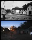
| Date: | 05 07 2012 |
|---|---|
| Description: | Dusk in downtown Beetown. View down curved street towards an illuminated Hamms sign on a building along the block on the left. A sign that reads "Beetown F... |
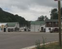
| Date: | 07 27 2012 |
|---|---|
| Description: | A view down Main Street in Beetown on an overcast day. |

| Date: | 04 25 2012 |
|---|---|
| Description: | A view from an intersection in the main business district. |
| Date: | |
|---|---|
| Description: | A vintage view and a modern view of downtown crossroads, presented as a pair. The vintage view includes signs advertising Texaco Perry Gas, Minnows and Wor... |

| Date: | |
|---|---|
| Description: | A vintage view and a modern view of a brick school building, presented as a pair. The vintage view shows the District #4 School. The modern view shows the ... |

| Date: | |
|---|---|
| Description: | A vintage view and a modern view down Main Street, presented as a pair. |

| Date: | |
|---|---|
| Description: | A vintage view and a modern view of the downtown business district Blue River, presented as a pair. |

| Date: | 1942 |
|---|---|
| Description: | This map shows a paper city laid out in 1836 on the Wisconsin River, now the site of Wyalusing State Park, Grant County. The upper right corner includes a ... |

| Date: | 1900 |
|---|---|
| Description: | This photocopy map shows labeled streets and plats. |

| Date: | 1947 |
|---|---|
| Description: | Map showing plats, streets, and the public square. The bottom margin of the map includes registration and certifications. |
If you didn't find the material you searched for, our Library Reference Staff can help.
Call our reference desk at 608-264-6535 or email us at: