 Filter: Categories of Wisconsin Historical Images
Filter: Subject of Streets
Filter: County of Grant
Filter: Year of 1800-1899
Filter: Categories of Wisconsin Historical Images
Filter: Subject of Streets
Filter: County of Grant
Filter: Year of 1800-1899
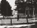
| Date: | 1880 |
|---|---|
| Description: | Slightly elevated view of street corner, with two buildings that have been destroyed by a fire, a brick fence, and some trees. There is a wooden cart in th... |
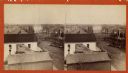
| Date: | 1865 |
|---|---|
| Description: | Stereograph of an elevated view of Court House Square in Lancaster. |

| Date: | 1835 |
|---|---|
| Description: | Plat for a proposed Sinsinawa City (never built), in Grant County, Wis. When it became clear in the mid-1830s that Wisconsin Territory would be established... |

| Date: | 1850 |
|---|---|
| Description: | This map of Cassville shows plat of town, roads, and the Mississippi River. Relief is shown by hachures. The map includes an inset map of a Plat of townshi... |
| Date: | 1895 |
|---|---|
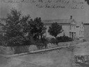
| Description: | Pedestrian walking on the snowy street in front of Daniel Fitch Brown's house. |

| Date: | 06 1845 |
|---|---|
| Description: | This map is pen-and-ink on paper and shows the numbers, dimensions, and acreages of lots, as well as survey monuments and streets. Also included is a certi... |
If you didn't find the material you searched for, our Library Reference Staff can help.
Call our reference desk at 608-264-6535 or email us at: