 Filter: Categories of Wisconsin Historical Images
Filter: Subject of Streets
Filter: County of Jefferson
Filter: Categories of Wisconsin Historical Images
Filter: Subject of Streets
Filter: County of Jefferson

| Date: | 09 1884 |
|---|---|
| Description: | Sanborn map of Fort Atkinson including South Water and Milwaukee Streets. |
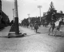
| Date: | 07 28 1901 |
|---|---|
| Description: | View down Main Street, facing east, during Pawnee Bill's Circus Wild West Parade. |
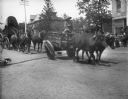
| Date: | 07 28 1901 |
|---|---|
| Description: | View of Pawnee Bill's Circus Parade. |
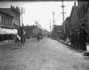
| Date: | 06 03 1901 |
|---|---|
| Description: | View of Pawnee Bill's Wild West Parade, looking west down Main Street. |

| Date: | 06 17 1900 |
|---|---|
| Description: | View down street of German soldiers on a march from the depot of the Chicago, Milwaukee, and St. Paul Railroad on their way to Turner Hall. |

| Date: | 1870 |
|---|---|
| Description: | Bird’s-eye view map. "Looking north east." Indexed for points of interest. Shows homes, businesses, and the Bark and Rock River. Streets running west to ea... |

| Date: | 1920 |
|---|---|
| Description: | Shows ward boundaries, corporation limits, plat of town, land ownership by name, local streets, parks, railroads, and parts of Rock River. Wards appear in ... |

| Date: | 1947 |
|---|---|
| Description: | Lower left hand corner features a legend. "Drawn 1938, revised 1947." Shows water mains, hydrants, corporation limits, city ward divisions, fire proof buil... |

| Date: | 1976 |
|---|---|
| Description: | Includes index of streets and of local businesses. Shows location of Citizens State Bank, roads, highways, railroads, parks, cemeteries, and city sanitary ... |

| Date: | 1912 |
|---|---|
| Description: | View down street from the end of a bridge. On the left is a service garage, post office and millinery. On the right is a shoe and repair shops, and other c... |
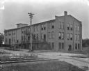
| Date: | |
|---|---|
| Description: | View across railroad tracks of the Drew Carrier Company, which is a three-story brick building with exterior stairs and a ramp leading up to a second floor... |
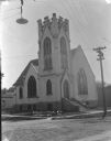
| Date: | 1912 |
|---|---|
| Description: | View from street of the English Lutheran Church on a corner, showing front and left side of the building. The entrance is under a square bell tower, which ... |
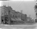
| Date: | 1912 |
|---|---|
| Description: | View from intersection of businesses along the left side of Monroe Street. A group of men are standing at the door of the drugstore on the corner, which ha... |
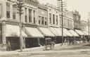
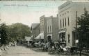
| Date: | 1900 |
|---|---|
| Description: | Photographic postcard of a view along left side of Monroe Street, showing horse-drawn vehicles parked along the curb in front of storefronts. Caption reads... |

| Date: | 06 1959 |
|---|---|
| Description: | This blue line print map shows lot and block numbers and dimensions, fair grounds, schools, court house, parks, and the street numbering system. The Crawfi... |
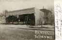
| Date: | |
|---|---|
| Description: | View across snowy, unpaved street towards the storefront. Caption reads: "R.H. Mill, Sullivan, Wis." |
| Date: | |
|---|---|
| Description: | Partially colorized postcard view down Jefferson Street. People are gathered in front of one of the storefronts on the right, and horse-drawn vehicles are ... |

| Date: | 1857 |
|---|---|
| Description: | This map shows lot and block numbers, buildings, some land ownership, wards, waterways, streets, railroads, brick yards, and cemeteries. It includes an ind... |

| Date: | 04 29 1979 |
|---|---|
| Description: | A man is walking through a flooded Dairy Queen parking lot in the downtown area, while cars are driving down the street. The sign in the window of the Dair... |
If you didn't find the material you searched for, our Library Reference Staff can help.
Call our reference desk at 608-264-6535 or email us at:
