 Filter: Categories of Wisconsin Historical Images
Filter: Subject of Streets
Filter: Subject of human settlements
Filter: Year of 1800-1899
Filter: Categories of Wisconsin Historical Images
Filter: Subject of Streets
Filter: Subject of human settlements
Filter: Year of 1800-1899
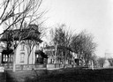
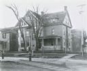
| Date: | 1890 |
|---|---|
| Description: | Several houses at the intersection of Wilson Street and Monona Avenue with the home of Simeon Mills, one of Madison's most prominent citizens, on the corne... |
| Date: | 1865 |
|---|---|
| Description: | University of Wisconsin-Madison campus showing the first three buildings on campus, South Hall (left), University Hall [Bascom Hall] (center), and North Ha... |
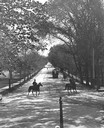
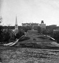
| Date: | 1896 |
|---|---|
| Description: | Tree-lined State Street from Bascom Hill on the University of Wisconsin-Madison campus. Traffic on State Street includes two well-dressed gentlemen on hors... |

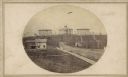
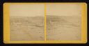
| Date: | 09 1871 |
|---|---|
| Description: | Bird's-eye view of Peshtigo, before it was destroyed by fire on the night of October 8, 1871. |
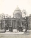
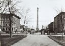
| Date: | 1899 |
|---|---|
| Description: | View from street through gates towards the Third Wisconsin State Capitol, the second in Madison, as seen from East Washington Avenue. The iron fence and st... |

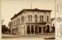
| Date: | 1898 |
|---|---|
| Description: | University Heights from the Chemistry Building on University Avenue. View includes the University of Wisconsin-Madison football field, on the former site o... |

| Date: | 1870 |
|---|---|
| Description: | This bird's-eye-view map shows roads, a river with boats, and homes. The bottom margin of the map includes an index. |
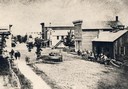
| Date: | 1871 |
|---|---|
| Description: | Street scene showing destruction after Peshtigo fire. |

| Date: | 1881 |
|---|---|
| Description: | Bird's-eye map of Marinette, with insets. |
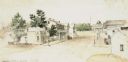
| Date: | 1851 |
|---|---|
| Description: | A watercolor view of Madison. Prominent on the left side of King Street is the Madison Hotel. |
| Date: | 1880 |
|---|---|
| Description: | The Opera House at the corner of Washington (now Main) and North Mill Streets. A sign at the back of the building reads: "Printing." A barber pole is in fr... |
| Date: | 1868 |
|---|---|
| Description: | View from unpaved Wisconsin Avenue looking east toward the third Wisconsin State Capitol sometime prior to the completion of the dome (1869). The portion o... |
| Date: | 05 12 1896 |
|---|---|
| Description: | Charles N. Brown residence, southeast corner of the intersection of Frances and Langdon Streets. On the left is 263 Langdon Street. Both structures were de... |

| Date: | 1884 |
|---|---|
| Description: | A sign for Fauerbach's Brewery depicting a young woman and the brewery. |
| Date: | 1890 |
|---|---|
| Description: | The Madison water tower and farmers' market as seen through the stone gateway at the East Washington Avenue entrance to the Capitol Park. The building on t... |
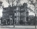
| Date: | 1879 |
|---|---|
| Description: | The facade of the McCormick family residence at 675 Rush Street, which takes up an entire block between Erie and Huron Streets. Cyrus Hall McCormick, Sr. h... |
| Date: | 1860 |
|---|---|
| Description: | Elevated view of Barstow Street looking north. View from the corner of Main Street, where the Eau Claire Book and Stationary Company later stood, looking n... |
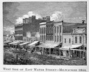
| Date: | 1844 |
|---|---|
| Description: | Illustration of the west side of East Water Street. |

| Date: | 1890 |
|---|---|
| Description: | Bird's-eye map of Ashland, viewed from Lake Superior, with insets of Prentice Park and Fishery. Population 16,000. Increase in Ten Years, 11,000. |
If you didn't find the material you searched for, our Library Reference Staff can help.
Call our reference desk at 608-264-6535 or email us at:
