 Filter: Categories of Wisconsin Historical Images
Filter: Subject of Suburbs
Filter: County of Dane
Filter: Categories of Wisconsin Historical Images
Filter: Subject of Suburbs
Filter: County of Dane

| Date: | 12 23 1953 |
|---|---|
| Description: | Aerial view of Crawford Heights looking northeast along Nakoma Road, across the West Beltline. The photograph shows Midvale Boulevard and Lake Mendota appe... |

| Date: | 12 22 1953 |
|---|---|
| Description: | Aerial photograph of Crawford Heights looking west along the West Beltline. The photograph shows Nakoma Road, Midvale Boulevard, Cherokee School, and the A... |

| Date: | 12 23 1953 |
|---|---|
| Description: | Aerial view of Crawford Heights looking west along the West Beltline. The photograph shows Nakoma Road, Midvale Boulevard, Cherokee School, and the Arboret... |

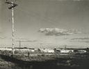
| Date: | 12 23 1953 |
|---|---|
| Description: | Aerial view of Crawford Heights looking north by northwest along the West Beltline with Cherokee School and the Arboretum at lower right and Lake Mendota a... |

| Date: | 07 03 1954 |
|---|---|
| Description: | View of the flooded yard of Mr. and Mrs. Willard Stormer at 829 Burbank Place in the Garden Homes subdivision of Madison. |

| Date: | 07 03 1954 |
|---|---|
| Description: | Mr. and Mrs. Willard Burbank look at the flooded basement of their home at 829 Burbank Place in the Garden Homes subdivision of Madison. |

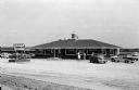
| Date: | 11 18 1954 |
|---|---|
| Description: | Exterior view of a large service station with three groups of gasoline pumps in front, located at 2629 West Broadway in Monona. The building has a sales ro... |
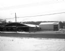
| Date: | 02 01 1957 |
|---|---|
| Description: | A metal store building and a metal warehouse building at 3320 University Avenue. In the background is a tree lined ridge. In the foreground is a two-lane r... |
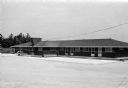
| Date: | 07 21 1958 |
|---|---|
| Description: | Exterior view of the Waterfall Motel and Restaurant, a one-story building with seven large picture windows. A free-standing sign that reads "Waterfall Rest... |
| Date: | 07 21 1958 |
|---|---|
| Description: | The Waterfall, an 18 unit motel and restaurant, was opened in 1958 and owned and operated by Oregon's village president, F.E. Madsen, and John Struck. A wa... |

| Date: | 06 08 1960 |
|---|---|
| Description: | Blueprint plat of Sunset Hills sub-division. |

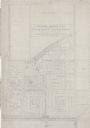
| Date: | 1903 |
|---|---|
| Description: | Shows lot numbers and dimensions. "Issued May 31, 1903" -- Inscribed in ink. Oriented with north to the upper right. Includes text. Labelled streets are "R... |
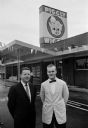
| Date: | 05 19 1959 |
|---|---|
| Description: | Two men are posing in front of a new Piggly Wiggly grocery store. The new store was located in Middleton at the intersection of Gateway Street and Universi... |
| Date: | 1960 |
|---|---|
| Description: | New residential construction on the outer southwest edge of Madison. |
| Date: | 1938 |
|---|---|
| Description: | Architectural drawing of the Sunset Village neighborhood on the West side of the city of Madison. The poster description reads: A proposed master plan for ... |

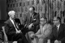
| Date: | 01 14 1960 |
|---|---|
| Description: | Madison Fire Chief Edward Page, center, presents a plaque from the International Fire Chiefs Association to Maple Bluff's volunteer fire department for ach... |
| Date: | 02 23 1960 |
|---|---|
| Description: | Once a year, members of the Shorewood Hills village board and members of the Blackhawk Country Club board of directors get together for a social evening to... |

| Date: | 1920 |
|---|---|
| Description: | This map shows the Nakoma neighborhood in Madison including the "Proposed Golf Ground." The map reads: "Nakoma--the Suburb Superb." The map includes texts ... |

| Date: | 1906 |
|---|---|
| Description: | This map shows shows streets, subdivisions, railroads, places of interest including the State Capitol, the University of Wisconsin, Camp Randall, Henry Vil... |

| Date: | 1966 |
|---|---|
| Description: | This map shows streets, highways, railroads, parks, colleges, cemeteries, county clubs, University of Wisconsin, Truax Field, Middleton, Shorewood Hills, M... |
If you didn't find the material you searched for, our Library Reference Staff can help.
Call our reference desk at 608-264-6535 or email us at: