 Filter: Categories of Wisconsin Historical Images
Filter: Subject of Suburbs
Filter: Subject of cities and towns
Filter: Community of Madison
Filter: Categories of Wisconsin Historical Images
Filter: Subject of Suburbs
Filter: Subject of cities and towns
Filter: Community of Madison
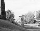
| Date: | 1955 |
|---|---|
| Description: | A man who does odd jobs around his neighborhood mows a banked lawn. |
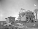
| Date: | 03 03 1930 |
|---|---|
| Description: | Steve Schmidt house under construction in Sherman Park subdivision. The house is located at 1406 Farragut Street. |
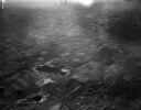
| Date: | 04 21 1948 |
|---|---|
| Description: | Aerial photograph of the west side of Madison and the western edge of Lake Mendota. Taken over the west side of Madison looking northwest toward Middleton. |
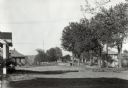
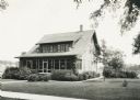
| Date: | |
|---|---|
| Description: | View of Nakoma Road looking northeast, with several houses and trees, and automobiles parked on the street. There is a woman standing on the steps of a por... |

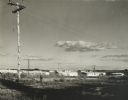
| Date: | 1980 |
|---|---|
| Description: | Elevated view of construction and development taking place in a housing community known as Tamarack Trails Subdivision. |

| Date: | 1980 |
|---|---|
| Description: | Front view of a house under construction in the Tamarack Trails Subdivision. |
| Date: | 06 1926 |
|---|---|
| Description: | Front yard with shrubs and evergreens around foundation of suburban house. |

| Date: | 09 13 1952 |
|---|---|
| Description: | View of the first of the thousands of people who toured the 18 new homes erected by 15 builders at Nakoma Road and the West Beltline. The Parade of Homes w... |

| Date: | 1903 |
|---|---|
| Description: | Shows lot numbers and dimensions. "Issued May 31, 1903" -- Inscribed in ink. Oriented with north to the upper right. Includes text. Labelled streets are "R... |
| Date: | 1960 |
|---|---|
| Description: | New residential construction on the outer southwest edge of Madison. |

| Date: | 1966 |
|---|---|
| Description: | This map shows streets, highways, railroads, parks, colleges, cemeteries, county clubs, University of Wisconsin, Truax Field, Middleton, Shorewood Hills, M... |

| Date: | 1969 |
|---|---|
| Description: | This map is pen and ink on paper and shows the location of churches, local streets, railroads, parks, Middleton, Shorewood Hills, Monona, Maple Bluff, McFa... |

| Date: | 1968 |
|---|---|
| Description: | Three maps that show local streets, roads, railroads, parks, country clubs, the University of Wisconsin, Shorewood Hills, Maple Bluff, Monona, Truax Field,... |

| Date: | 1971 |
|---|---|
| Description: | This map shows streets, highways, railroads, parks, colleges, cemeteries, county clubs, University of Wisconsin, Truax Field, Middleton, Shorewood Hills, M... |

| Date: | 10 1911 |
|---|---|
| Description: | This map shows lot numbers, building lines, roads, trees, and Indian mounds. Relief is shown by contours. Includes manuscript annotations marking parks. |

| Date: | 1908 |
|---|---|
| Description: | A Sanborn map of the isthmus, which includes the map key. |
If you didn't find the material you searched for, our Library Reference Staff can help.
Call our reference desk at 608-264-6535 or email us at: